Read The
Current Issue
Deserted or Destroyed?
Immediately south of Jackson Hole, the Wyoming Range is a contradiction, with some sections overused and others rarely visited. What does that mean for its role in the Greater Yellowstone Ecosystem?
By Mike Koshmrl
Photography by Ben Graham
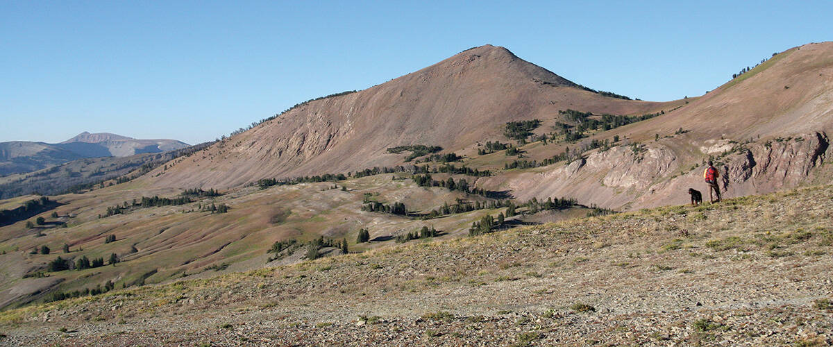
PAST THE CUT-off trail that works its way toward Cliff Creek, the imprints of horseshoes, manure, and a maintained trail quickly give way to scores of elk tracks, wolf scat, and deadfall. Although it is July, any indication that hikers have used the Wyoming Range National Recreation Trail south of Jackson Hole at any point since the snow melted off a month earlier is absent. While the trailhead is a mere half-hour drive from the Jackson Town Square, the solitude and ruggedness are expected. Kind of.
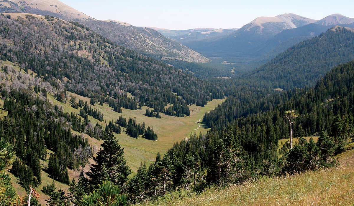
Wolverines, one of the hardest-to-spot mammals in North America, live in the Wyoming Range, which forms the southeastern arm of the Greater Yellowstone Ecosystem and has peaks that rise to over 11,000 feet. These mountains are perhaps the last place in the state where lynx live. Jackson resident and retired Bridger-Teton National Forest (BTNF) landscape architect Susan Marsh says that from the Fourth of July until the start of elk season (hunters travel to this range from across the state) if you pick your spot carefully, “You can see zero people. It’s pretty amazing.” Marsh would know as well as anyone: Over the years, she has written three books that included “Wyoming Range” in the title.
At the same time, the Wyoming Range has incurred the hefty hand of man, especially along its fringes. Dirt bikers and ATVers heavily use the range. Also, the U.S. Forest Service’s (USFS) mixed-used mandate of land management is clear here. Like many slices of the Northern Rockies, the range—some areas of which are in the Bridger-Teton National Forest, while other areas fall under the jurisdiction of the Bureau of Land Management—is fraught with land-use and wildlife controversies.
The southern reaches of gray wolf and grizzly range in the Lower 48 are here, but land managers and locals aren’t particularly welcoming to either species. There has been oil and gas development in the lower elevations of these mountains, and, in some areas, the effect of the industrial activity has been to wipe out the Colorado River strain of cutthroat trout from entire creeks. The federal government and the state have battled over whether to manage areas here for bighorn sheep or domestic sheep. Closures of motorized routes are often ignored (including on parts of the Wyoming Range National Recreation Trail, which is supposed to be for foot and horse traffic only the entirety of its seventy-five-mile length). In places, grazing livestock have overwhelmed alpine wildflower communities and fouled streams with E. coli bacteria.
This wear, and its contrast to adjoining wilderness areas and national parks, begs the questions: Is the Wyoming Range a functional wild ecosystem? And, if so, is it truly part of the Greater Yellowstone Ecosystem?
There has been oil and gas development in the lower elevations of these mountains, and, in some areas, the effect of the industrial activity has been to wipe out the Colorado River strain of cutthroat trout from entire creeks.
MANY JACKSON HOLE residents, who live in the range’s backyard, likely only know these mountains from reading headlines related to the aforementioned controversies. The Wyoming Range is not as sexy as the Tetons, but, at one hundred miles long, it’s easily double the size. It’s a gem of a place for outdoorsmen like me who like to hunt, fish, ski, and cover ground for the sake of seeing new sites. Despite the incursions of humans, sections of this range are incredibly remote, much more so than the majority of the Tetons.
Just a handful of miles from the Hoback Junction roundabout, the northern start of the Wyoming Range National Recreation Trail is at Bryan Flats. Depending on the time of year, expect to see horse trailers here or, more likely, nobody. Meandering along Willow Creek through monotonous, treed terrain for the first dozen miles, the trail passes through land that in the late 1970s conservationists advocated to become the Grayback Wilderness. Nothing happened then, but, through the ongoing Wyoming Public Lands Initiative, the discussion has re-emerged. The lands initiative, in theory, has promise to culminate in a bill that would create new wilderness areas in the state.
(The last time a new area was designated as wilderness in Wyoming was 1984.) In Marsh’s estimation, much of the country in the Wyoming Range has attributes—like wide-open landscapes where the effects of mankind are relatively nil—that make it eligible to be designated a Wilderness Area. “They certainly could be, but it’s up to public opinion to determine whether or not that ought to happen,” Marsh says.
Public opinion would likely be against a wilderness designation, which is the strictest protection federal land can get. Nothing mechanized—this includes mountain bikes, dirt bikes, and snowmobiles, among other things—is allowed in a wilderness area. And the east side of the Wyoming Range is a mecca for snowmobiling. “Those people have to have someplace to go, too,” Marsh says. “You can’t just make it all wilderness.” The locals would fight any wilderness plan “tooth and nail,” says Cotton Guio, a Big Piney cattle rancher whose family has recreated in the Wyoming Range for six generations. “I don’t think anybody would be for that. There’s a lot of wilderness in Wyoming, and unless you’re twenty years old and in really good shape, you’re only going to see a portion of it.”
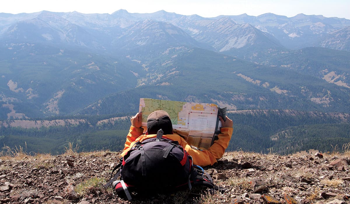
THE FIRST TRUE climb of the Wyoming Range National Recreation Trail is at Pickle Pass, which divides the Greys and Hoback River drainages. Herds of cow elk with still-tiny, vulnerable calves at their sides scatter at our approach. To the northeast, some forty-five miles away, the Teton Range, unmistakable at even this distance, cuts the horizon. The hiking is arduous and the trail loose. Switchbacks are sparse and, the higher we climb, increasingly difficult to follow. Traveling north to south, the trail gains nearly 17,000 feet over its seventy-five miles. In places, it traces the range’s crest at 9,000 or 10,000 feet in elevation. Throughout, especially up high, the trail is challenging to follow without a compass, quad map, and stellar navigation skills or a GPS. (Lacking the former, we opt for the technological solution.) Trail maintenance, even if the USFS had the manpower for it, would be a challenge with the heavy clay soils that dominate this region. “The trail was designed for foot and horse use,” Marsh says, “but a lot of it really hasn’t been engineered at all. A lot of it’s just kind of random.”
The grade, looseness, and deadfall—and a prohibition against motorized travel—weren’t enough to deter a group of motorbikers from riding onto the trail near the headwaters of Cottonwood Creek, some forty miles south of the Bryan Flats trailhead. We don’t see the riders, but their passage is spelled out clearly in the mud. A legal motorized trail about five miles away may explain this illegal excursion, which, judging by the complex terrain, doesn’t look like it could have been much fun. Tracks go over things I never would have imagined a dirt bike could handle.
Illegal motorized use like this can marginalize habitat for species like elk and mule deer, says Steve Kilpatrick, a Wyoming Game and Fish expat who now heads the Wyoming Wild Sheep Foundation. “There’s places where there’s just a ton of motorized access,” Kilpatrick says. “You’re just not going to see wildlife [in these areas]. As I get older, I can’t go to the high peaks like I used to. And I’m not going to request that someone give me motorized access to get there by building a two-track road. I’m not going to do that, because I know the impacts on the critters that live there, I know the visual impacts on the landscape, and I know the impacts to people who work so hard to hike or ride a horse there.”
Along one four-mile stretch of the Wyoming Range Trail, between Roaring Fork Lakes and North Piney Creek, motorized use has taken over. Where a primitive trail once weaved through the landscape, denuded, rutted, and sometimes paralleling four-wheeler trails scar the land today. “It used to be a single-tracked trail until about 1995, ’96 in there,” Marsh says. Now, “It’s a mess, and it’s not keeping with the purpose of the trail, which was supposed to be for nonmotorized uses. And it’s not legal, but the ranger district has never done anything about it to try to close it off, so the use continues.” The BTNF’s Big Piney District Ranger, Don Kranendonk, would not consent to an interview for this article, despite repeated requests. Guio, who’s a dirt biker himself, confirms that locals value motorized access into these mountains. “I don’t think there’s any damage in that practice, and I think they’re doing a service,” Guio says. “When you close trails, it becomes such a mess of woods that you can’t even find the trail. I think those bikers are doing a good thing.”
Switchbacks are sparse and, the higher we climb, increasingly difficult to follow. Traveling north to south, the trail gains nearly 17,000 feet over its seventy-five miles. In places, it traces the range’s crest at 9,000 or 10,000 feet in elevation.
DROPPING DOWN FROM 8,500-foot-high McDougal Gap (the only place along the trail’s length that is bisected by a road), we’re back in an area where there are no human footprints, much less dirt-bike tracks. Still, other signs of human influence—in the form of cow patties and the free-ranging black heifers themselves—are everywhere. Livestock grazing has been part of the Wyoming Range for generations. At grazing’s peak, Kilpatrick says 100,000-plus domestic sheep ranged these mountains’ highlands. Cattle roam at lower elevations.
Today there is such a thing as “rangeland science,” which includes studying grazing, but during the decades of the heaviest grazing in the Wyoming Range, rangeland science was in its infancy. Because of that, there were subalpine wildflower communities that were nearly destroyed. Thirty-plus years later, they’re still recovering. “The tall forb communities we just learned about twenty-five years ago are extremely sensitive ecologically,” Kilpatrick says. “They’re easily disturbed and easily overgrazed by sheep. And I’m not blaming anyone, because we didn’t know what was going on, but we started to lose a lot of those communities.”
Because many flower species are struggling to return, much of the range is nearly a monoculture. Mule’s ears, a native flower species that is yellow in color, thrives in grazing areas because neither domestic sheep nor wildlife find it palatable. At the right time of year, the range’s open meadows are a sea of yellow, Kilpatrick says. “[Mule’s ears] should be on the landscape, but not in a dominant form,” he says. “In the Wyoming Range, there’s more of it dominating the landscape than any other place I’m aware of.”
Range monitoring, however, suggests that the diversity of flowers has either stabilized or is improving, and the percentage of bare, once-trampled ground is on the decline, Marsh says. And by a lot of other measures, the prospects for the range look good. For years, one of the gravest threats to the land’s wildness was oil and gas development. In 2009, U.S. Sen. John Barrasso shepherded passage of the 2009 Wyoming Range Legacy Act, which designated 1.2 million acres of the BTNF off-limits to oil and gas.
(The act was envisioned and developed by the late Sen. Craig Thomas; Sen. Barrasso brought it to the finish line.) In 2012, the Trust for Public Land bought out the oil and gas drilling leases that had already been issued in Noble Basin, where the headwaters of the Hoback River are located. This $8.75 million purchase stopped a plan that would have peppered ninety square miles of the range with as many as 136 gas wells on seventeen pads. This past winter, BTNF leaders invalidated leases on sixty-two square miles of the range west of Big Piney and Merna. In doing this, the forest’s planners pointed to the intangible benefits of maintaining a wild landscape and the recreational uses it supports. Their decision was, in large part, driven by the will of nearby residents who in no uncertain terms said no more drilling in their backyard mountain range.
The Wyoming Range is not as sexy as the Tetons, but, at one hundred miles long, it’s easily double the size. It’s a gem of a place for outdoorsmen like me who like to hunt, fish, ski, and cover ground for the sake of seeing new sites.
BUT THE HAND-size canine tracks we see imprinted in the mud along Willow Creek likely wouldn’t be here if the state of Wyoming had its way. The Snake River Canyon and the highway to Pinedale, both of which are on our backside, mark the northern edge of a “predator zone,” where wolves can be shot on sight anytime of year and without licenses or restrictions. When I hiked the National Rec trail in 2016, wolves in Wyoming were protected from that persecution by the Endangered Species Act. In March 2017, though, a ruling by the U.S. Court of Appeals for the District of Columbia ended those protections, setting the stage for restoring the predator zone.
The resistance to safeguarding wolves stems in good part from livestock grazing in the Wyoming Range and the agricultural roots of Star Valley and the Green River Basin, which flank these mountains. This past summer, sheep ranchers with BTNF grazing permits lost dozens of ewes and lambs to wolves in the northernmost reaches of the range. This happened just south of the Snake River, about a day’s hike from where we admired Canis lupus tracks. “Definitely since wolves were relisted as an endangered species, we’ve seen an expansion further south into the Wyoming Range,” Wyoming Game and Fish Department large carnivore manager Dan Thompson says. “We’ve seen expansion of grizzly bears as well.”
At the time this magazine is going to press, grizzlies, Ursus arctos horribilis, are still listed as a “threatened” species that cannot be hunted. But delisting grizzlies—removing them from the endangered species list—has been proposed. If this proceeds, agreements with the U.S. Fish and Wildlife Service will give Wyoming broad latitude in how they manage bears in places on the Greater Yellowstone Ecosystem’s periphery. The state does not plan to manage grizzlies like they have wolves, as “predators” to be killed indiscriminately, but no safeguards are in place to prevent Wyoming from allowing hunters to take this range’s grizzly population down to very few or even zero.
BACKPACKING THE WYOMING Range trail is a grueling endeavor. A hobbled hiking partner led to one early exit and lengthy hitchhiking endeavor from Little Granite Creek to McDougal Gap. On another attempt, time constraints kill our aspirations to complete the route in full. But the approximately fifty miles I do see are enough to convince me that these mountains, which start within eyeshot of the deck of my former Hoback Junction home, are an integral part of the Greater Yellowstone Ecosystem. The landscape is vast, and, along much of the National Recreation Trail and beyond, the trails are primitive, wildlife abundant, and humans nonexistent for much of the year.
Gary Fralick, a Game and Fish wildlife biologist who knows this range intimately, says areas of it provide immensely important habitat for species like mule deer, elk, and grizzly bears. “It provides connectivity between southwestern Wyoming and the Greater Yellowstone Ecosystem,” he says. Thanks to the Wyoming Range, “Animals can move from there into Montana, and even into Canada. That’s one of the more important contributions of the Wyoming Range: connectivity.”
Marsh says the Wyoming Range has “every right” to be considered part of the Greater Yellowstone area. “Right now, a lot of the problems—illegal motorized use, [invasive] weeds, a few other sore spots—they’re all kind of minor in the bigger picture,” she says. “I would just like to see that contained. I think the area has the capacity to have a lot more human use without damage. We don’t want to encourage the hordes, but that’s just not going to happen.” Which means I can try to hike the entirety of the Wyoming Range trail again and likely see just as few people. I plan on it.
Wyoming Range Hiking Isn’t All Arduous
Not everyone has the time, ability, or desire to take on the rugged seventy-five-mile Wyoming Range National Recreational Trail in its entirety. There are dozens of trailheads—some only a half-hour drive from Jackson—and hundreds of miles of trails elsewhere in the range. For a full rundown of options, pick up Susan Marsh and Rebecca Woods’ Beyond the Tetons. Here are several ideas, though.
Ann’s Ridge
The Hike: This 2-mile hike up Ann’s Ridge is easy and, eventually, scenic. After winding through aspen and conifer stands, it tops out on the open slopes of a small, knobby mountain that rises up over Bryan Flats. Continue another third of a mile to the very crest of the ridge for views of the Tetons.
Insider Tip: Don’t let your dog drink out of the algae-choked pond midway to the summit. Mine did once and got horrifically sick.
Directions: Head south from Jackson on U.S. 191/89/26. At Hoback Junction, continue on U.S. 191 toward Pinedale for about 3 miles. Turn right onto Bryan Flats Rd. (there is a large sculpture of a bull moose at the turn). Continue on the road for a mile to the Bryan Flats Trailhead’s large parking lot.
Bailey Lake
The Hike: This 9.6-mile out-and-back hike to one of the northern Wyoming Range’s few lakes starts uphill, gaining 340 feet from the parking lot on the way to the Snake/Greys River divide.
Insider Tip: Fish for both cutthroat trout and a few grayling here.
Directions: Head south from Jackson on U.S. 191/89/26 for 13 miles to Hoback Junction. Continue 23 miles to Alpine on U.S. 26. Just before Alpine Market, turn left on Grey’s River Rd. In 8.3 miles, turn on Forest Service Road 10124. Bailey Lake Trailhead is 14 miles down this road.
Cliff Creek Falls
The Hike: Passing spruce stands and ample wildflowers, the trail gains 1,135 feet over 6 miles to 68-foot-high Cliff Creek Falls. The Marsh and Woods hiking book describes the cascade as a “two-tiered silver spray” that pours over a “spruce-shadowed cliff.” The sun is often in a position to create a rainbow in the falls’ spray.
Insider Tip: Continue 1.7 (steep) miles to Cliff Creek Pass, seated in the rolling high country of Hog Heaven Meadows, for beautiful views in all directions.
Directions: Head south from Jackson on U.S. 191/89/26 for 13 miles to Hoback Junction. Continue on U.S. 191 toward Pinedale for 14.8 miles. Turn right onto Cliff Creek Rd./Forest Road 30530. Cliff Creek Trailhead is at the south end of the junction of Cliff Creek Rd. and Sandy Marshall Creek Rd./30531. – Mike Koshmrl
