Read The
Current Issue

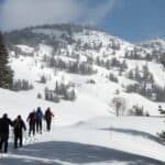
Hike-to High Points
These four summits don’t require any technical climbing and do offer expansive views.
// Story and photography By Dina Mishev
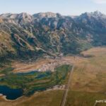
There are about 134 named peaks in Grand Teton National Park—and the Tetons are only one of six mountain ranges easily accessible from Jackson Hole. You could spend a lifetime hiking and climbing to summits here and never do the same one twice. Here are four summits, presented in order from least to most challenging, that are among our favorites because they do not require rock climbing skills and do offer amazing views. (And for anyone unable to hike to a summit, taking a lift to the top of one of the three ski resorts in the area—Snow King, Jackson Hole Mountain Resort, and Grand Targhee Resort—doesn’t diminish the views you get at the top.)
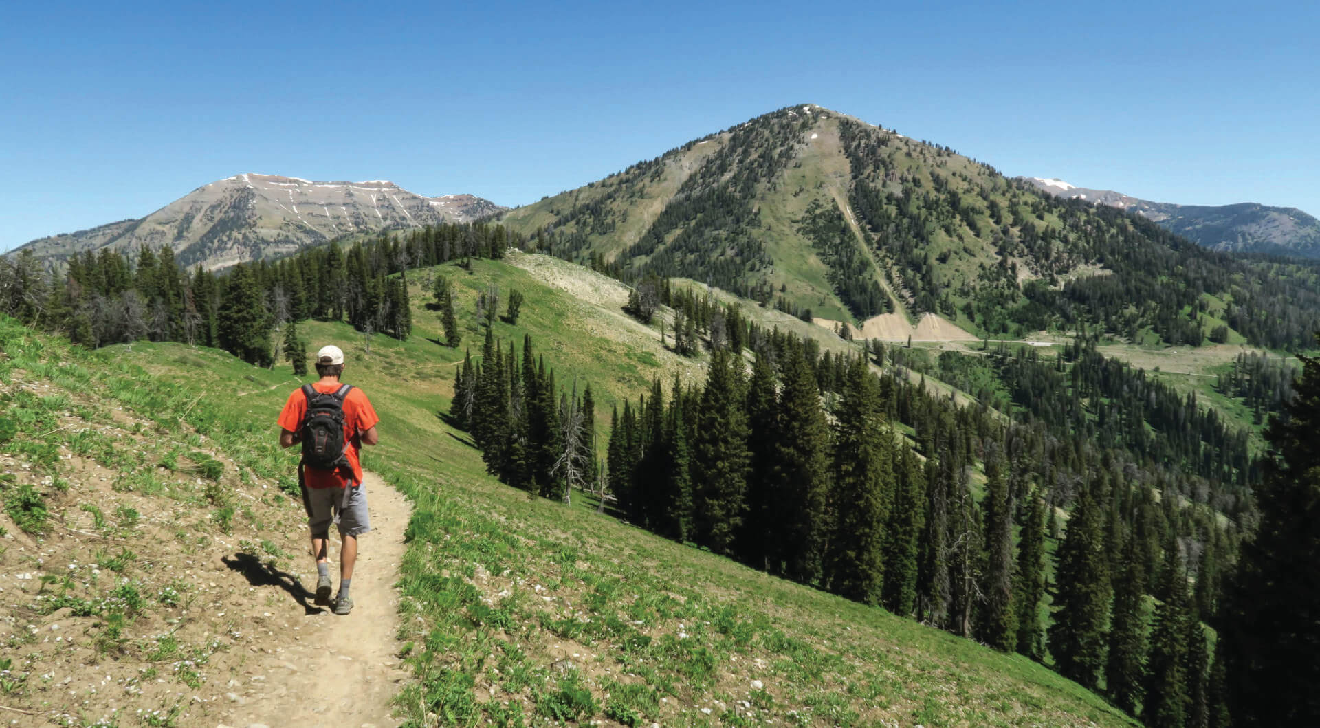
Local opinion is split on whether 9,279-foot Mt. Elly, on the south side of Teton Pass in the Bridger-Teton National Forest, is in the southern Tetons or the northern Snake River Range. Tom Turiano, a guide and historian who has published numerous books on skiing, hiking, and climbing in the various mountain ranges of the Greater Yellowstone Ecosystem, says it’s in the northern Snake River Range. We’re with him, but also, walking through wildflower-covered hillsides on the trail to the peak’s summit, we wonder why it matters. Southern Tetons or northern Snake Rivers—the views from Mt. Elly are equally rewarding.
Because it starts at the top of Teton Pass, which is 8,432 feet in elevation, the two-mile (one-way) Mt. Elly Overlook Trail is the easiest hike in the valley that delivers you to a summit from which you can see almost all of the mountain ranges that make Jackson Hole a hole. From the parking lot at the top of Teton Pass, the hike gains about 800 vertical feet, which isn’t nothing but is as close to nothing as you can get on a Jackson Hole summit hike.
The steepest part of the hike is the first quarter-mile from the parking lot. After that, the grade mellows and there’s scenery—the Snake River winding through the valley below, pine forest, blooming wildflowers—to distract you. In my book Best Easy Day Hikes Jackson Hole, I rate the Mt. Elly trail as the area’s best hike for wildflowers.
Getting there: Take WY22 west out of Wilson and drive five steep, twisting miles to the top of Teton Pass. Pull into the large parking area at the top; the Mt. Elly Overlook Trail starts at the parking area’s southeast end.
Many Jackson Hole peaks are named for their prominent features or after people. Mt. Elly got its name from a stuffed animal. In the mid-1900s, Mary Bird Young, a frequent guest at Trail Creek Ranch at the base of the eastern side of Teton Pass, always carried a stuffed elephant, Elly, in her backpack. One day, Young pulled Elly out of her pack to show her the magnificent views from an unnamed 9,279-foot summit. Her companions thought this amusing, and Mt. Elly was born.
Yes, you can take the Jackson Hole Mountain Resort aerial tram to the 10,450-foot summit of Rendezvous Mountain. And if you’re not capable of or up for a challenging 5.7-mile hike up 4,200 vertical feet, you should do that. But if you are up for a demanding adventure, the walk up Rendezvous Mountain via the Wildflower Trail and then the Cirque Trail takes you through masses of wildflowers and also groves of whitebark pine, and, about one-quarter of the way up, there’s even a shaded swing that begs you to sit and relax for a couple of minutes. Note that the Cirque Trail has steep, exposed sections that require the use of hands and feet.
While Rendezvous Mountain is easily the busiest summit on this list (remember: aerial tram), we’re OK with the crowds because they come with the benefit of being able to ride the aerial tram down. For free. Also, a cabin at the summit, Corbet’s Cabin, serves fresh-made waffles. About two-thirds of the way up this hike—at 9,095 feet—you reach the top of the Bridger Gondola and Rendezvous Lodge, which has a fine-dining restaurant, evening happy hour on its deck, and a market with grab-and-go foods like frittatas, pizza, and pastries. Just in case you need to rest.
Getting There: The Wildflower Trail starts beneath the aerial tram in the Jackson Hole Mountain Resort base area. At the top of the Bridger Gondola, the Wildflower Trail ends; from here, pick up the Cirque Trail.
The Cirque Trail takes you past some of the oldest whitebark pine trees at JHMR; some might be more than 1,000 years old.
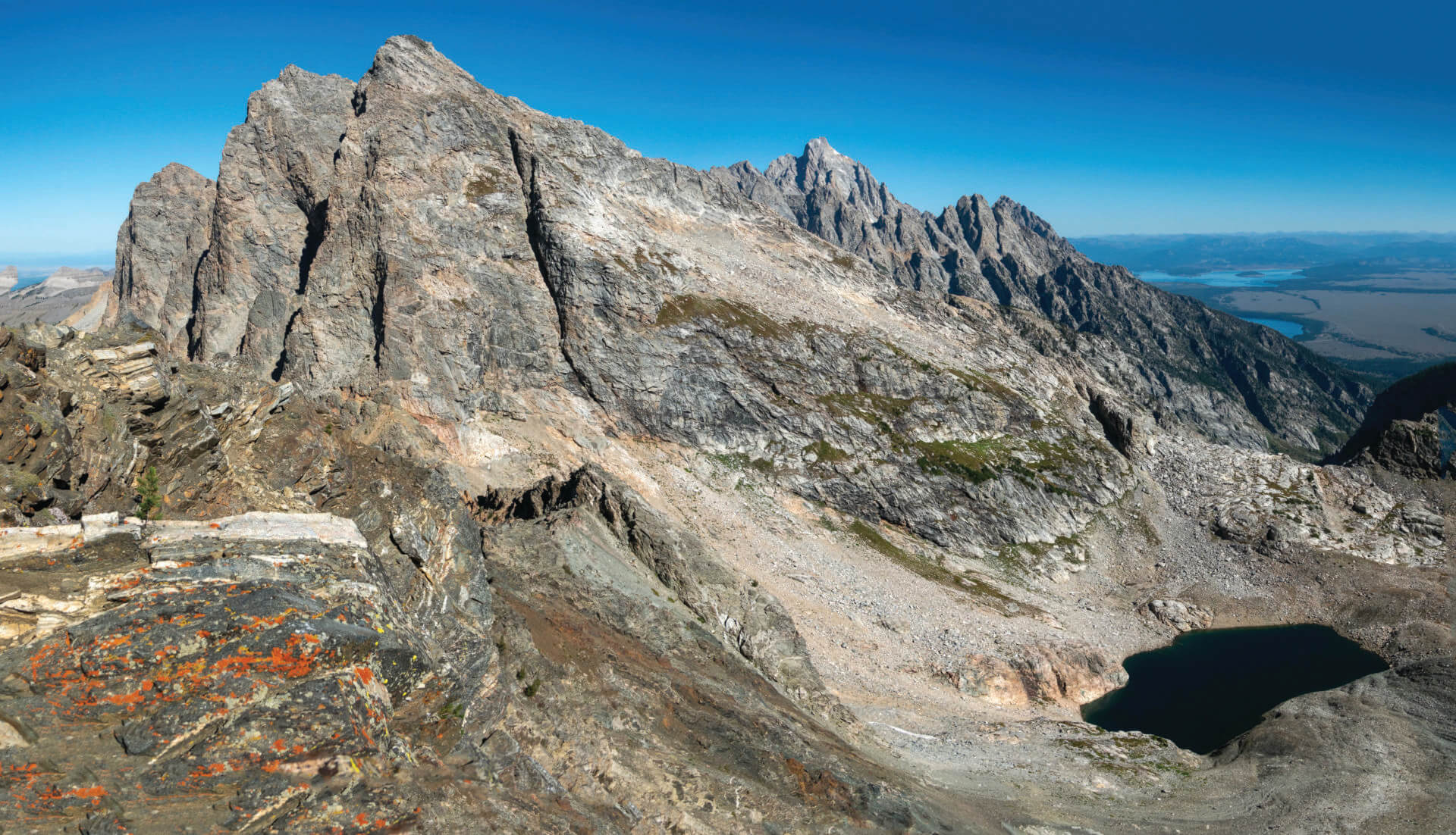
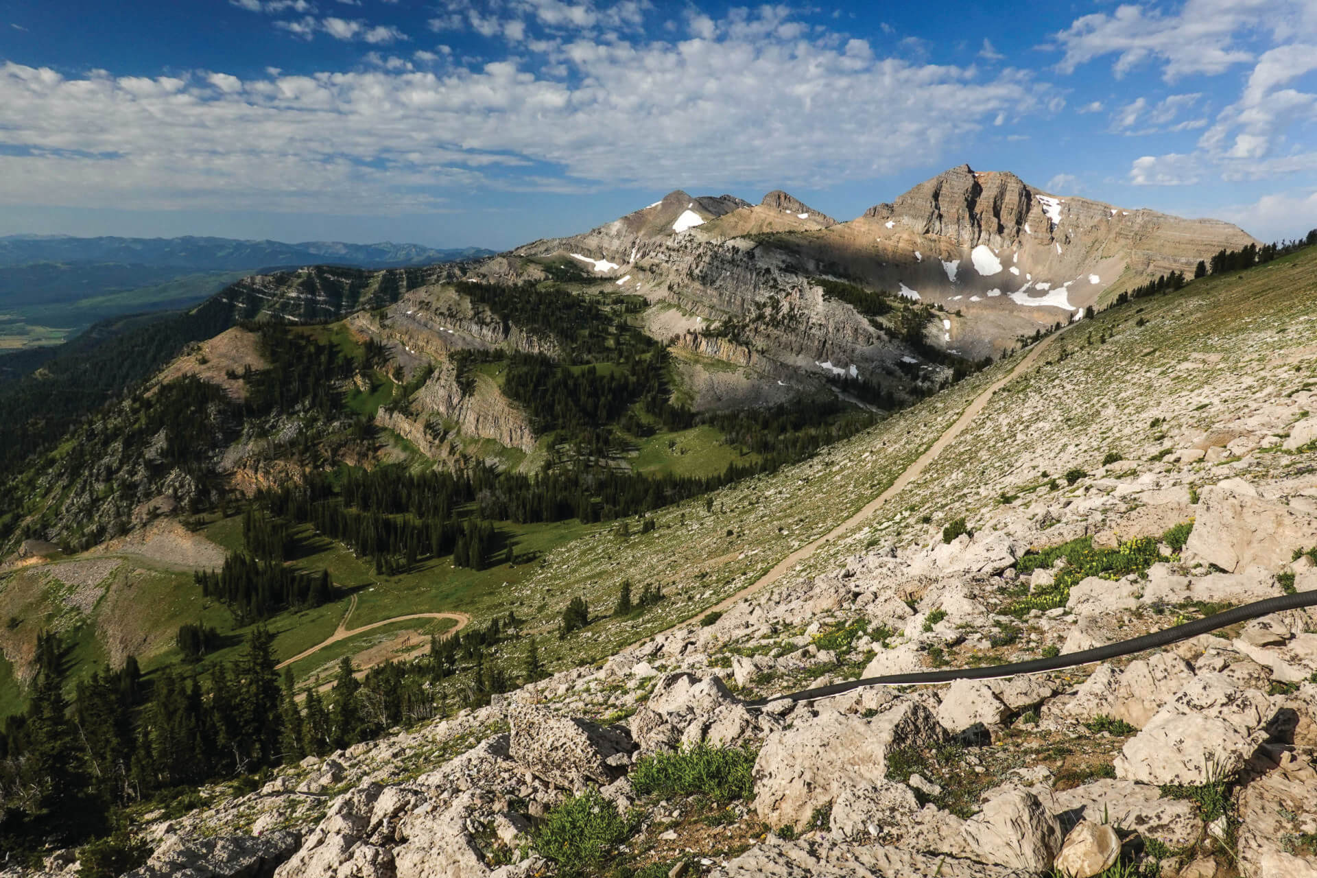
Static Peak in Grand Teton National Park has some of the best views of any summit in the Tetons, but you do have to work for them: the hike to its 11,303-foot-tall top is 8.5 miles each way and climbs (and on the return trip, descends) about 5,000 vertical feet. The reward? On clear days, you can see the Wind River Mountains and north into Yellowstone; directly to the north is the south face of Buck Mountain; behind Buck rises the Grand Teton; below you there’s Timberline Lake, its dark green waters looking frigid even on the warmest August day.
The trail to Static’s summit starts at the Death Canyon Trailhead. The first mile climbs several hundred feet to the Phelps Lake Overlook, where there are nice views down onto the eponymous lake, which was formed by retreating glaciers during the last ice age. The next mile is a little disheartening because you lose the vert you’ve just gained and then some, as the trail descends about 500 feet from the overlook to the mouth of Death Canyon. In a couple of miles, you’ll hit an old ranger patrol cabin and, just after passing it, take a right onto a trail marked with Static Peak Divide. Even though you’ve already hiked up about 2,000 vertical feet at this point, this is where the work really starts—it’s 3,000 vertical feet and about four miles from the patrol cabin to Static Peak Divide. At Static Peak Divide (10,790 feet), leave the main trail to follow a faint trail up the final 500 vertical feet to Static Peak’s summit.
Getting There: The Death Canyon Trailhead is off Moose-Wilson Road in Grand Teton National Park. Moose-Wilson Road and the Death Canyon Road/Trailhead are part of an ongoing construction project. Check nps.gov/grte/getinvolved/moose-wilson-corridor-project.htm for possible closures.
Static Peak in Grand Teton National Park has some of the best views of any summit in the Tetons
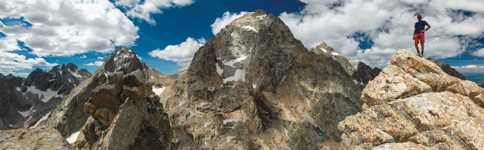
Disappointment Peak, an 11,623-foot-tall peak directly east of the Grand Teton in GTNP, is anything but a disappointment. In fact, it might have the best views of any summit in the Tetons. In the most excellent book A Climber’s Guide to the Tetons, authors Leigh Ortenberger and Renny Jackson write this of Disappointment’s summit:
“This summit view is truly remarkable, showing all of the peaks and pinnacles surrounding Garnet Canyon and Glacier Gulch, the heart of the Tetons, to great advantage.”
Disappointment’s summit does not come easy though. Not only does it require hiking up 5,000 vertical feet in about 5.5 miles, but the last 2,000 vertical feet require route-finding skills and being comfortable in and confident with exposure. An official GTNP hiking trail takes you 4.8 miles to Amphitheater Lake, but it ends there. A climber’s trail continues to the summit, and it has sections that are exposed and airy and require the use of hands and feet. People attempting to summit Disappointment have been seriously injured. There are places where, if you slip, you can fall hundreds of feet. Do not head up Disappointment Peak lightly.
The most often done route from Amphitheater Lake to the summit is to squeeze through “the keyhole,” make a couple of scrambly moves, and pop out into a gully that is steep but not super exposed. The gully takes you to the peak’s east face, where cairns mark a track through scree and rocks.
To get to the keyhole, follow the climber’s trail to the base of the headwall above Amphitheater Lake. The keyhole—a tiny opening in a pile of boulders—isn’t immediately obvious, but it is there. Just after scooching out of it, you’ll encounter the most exposed section of scrambling. Here, you will use your hands and feet for about 20 vertical feet. If members of your group aren’t good with exposure, it is possible to set up a belay above here. Expect it to take as long to reach Disappointment’s summit from Amphitheater Lake as it took you to get to Amphitheater Lake from your car.
Getting There: From the Lupine Meadows Trailhead in GTNP, take the Garnet Canyon Trail for 3.1 miles to the Amphitheater Lake Trail.
This mountain is named Disappointment Peak because the first white men to climb it—Phil Smith and Walter Harvey, in 1925—thought they were climbing the Grand Teton. By this time, the Grand had already been climbed—almost certainly by Native Americans (read more on page 138) and definitealy by several parties of whites, including the first woman, Eleanor Davis—but Smith and Harvey thought they were doing a new route. But, no. Upon reaching the summit, the men were disappointed to see a vast and complicated chasm between their perch and the 13,775-foot summit of the Grand. JH