Read The
Current Issue

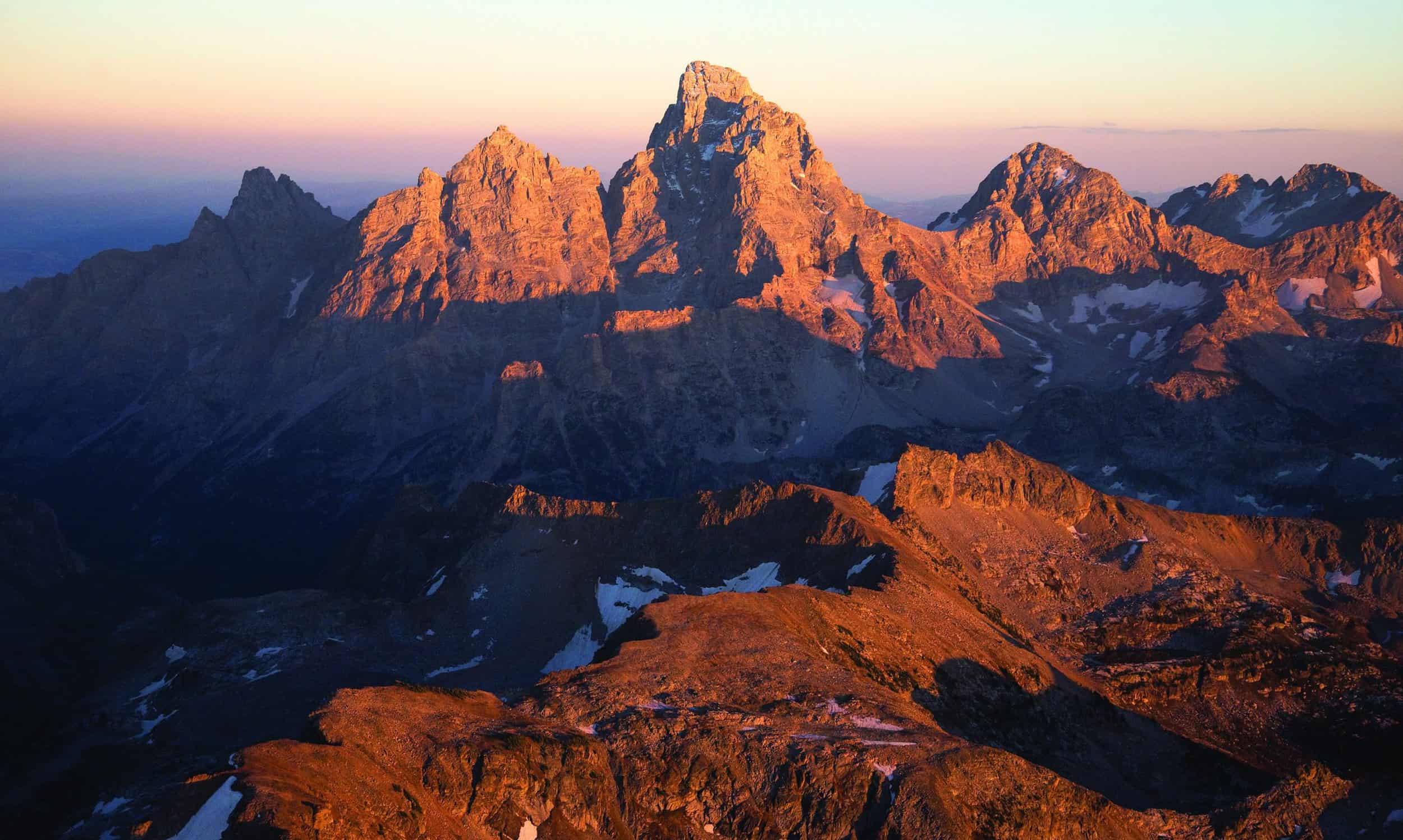
PHOTO BY BRADLY J. BONER
Scientists are widening our understanding of the Teton Fault that shapes and shakes Jackson Hole.
// By Mike Koshmrl
Ryan Thigpen’s aha moment came as he gazed at a plastic topographical Jackson Hole map hanging on the wall at a scientific research station on the shores of Jackson Lake. What if, the environmental sciences professor pondered, the Tetons and the fault line that created them once continued farther north, but were seared into oblivion by ancient movements of the North American plate over the gargantuan Yellowstone hotspot? “I was literally having a rain day at the AMK Ranch,” says Thigpen, a University of Kentucky professor. “I was just staring at the map and started thinking about it.” The trajectory, if you look at the map, lines up perfectly: Earlier eruptions of the magma chamber occurred in the present-day Snake River plain to the southwest in Idaho, but as the surface of the Earth inched along over the millennia, the massive volcanic feature would have passed right to the north of the Tetons. Think of dragging a piece of paper slowly over a stationary lighter. Thigpen’s suspicion, sprung from staring at a wall map years ago, has since evolved into an intensive examination of the theory that the Teton Fault and the mountain range itself were once much longer than what we see today.
“Large earthquakes on the Teton Fault are 1,000 times more likely than explosive eruptions in Yellowstone.”
—Chris DuRoss, U.S. Geological, Survey Research Geologist
Basic physics supports this idea, Thigpen says. Although the Cathedral group (the Grand Teton, Mt. Owen, and Teewinot Mountain) is the most dramatic-looking section of the Teton Range, the greatest point of vertical displacement at the fault actually occurs around Mount Moran. Here, dating of the exposed rocks suggests the fault moved somewhere between 8 and 10.5 miles since its formation millions of years ago. A geologic rule of thumb is that the length of a fault line is at least ten times its displacement, and that would mean the Teton Fault is 80 to 105 miles long, minimum. Current scientific literature says it’s just half that long—about 45 miles. It doesn’t add up. “Think about when you have a crack in your windshield,” Thigpen says. “The more that crack offsets, the longer that crack gets. It’s just physics.” Nothing is ironclad, but there’s early evidence coming out suggesting that the Tetons once even reached the modern-day Gallatin Range, which rises in earnest starting 45 miles or so north of where the Tetons fade into foothills. “It makes us wonder if those two ranges used to be linked,” Thigpen says. “We’ve been treated like the hypothesis is absurd, but I think it’s even more absurd to believe that along the Yellowstone hotspot there were never mountain ranges. If you look north of it and you look south of it, there are all these incredible mountain ranges, and all of them stop right at the edge.”
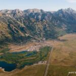
Thigpen’s theory is one piece of a flurry of scientific inquiry into the most consequential geologic feature in Jackson Hole: the Teton Fault. Appreciate the view and having a national park in your backyard? Thank the fault. Although Thigpen’s theory is still on the drawing board and much fieldwork remains to prove it, there’s plenty about the lengthy zone of compression that created the Tetons that’s undisputed. The Teton Fault is what’s called a normal fault or a dip-slip fault, and it’s a product of the stretching of the crust, specifically a fracture in two giant blocks of rock that are pressed up against each other. Although it’s been more than 5,000 years since the last big movement, the fault is active. Its movement occurs all at once, though it calculates out to somewhere between 0.8 to 1.1 millimeters per year averaged over time. “The fault is essentially locked,” says U.S. Geological Survey research geologist Chris DuRoss, who excavated the Teton Fault where it runs past Jackson Hole Mountain Resort in 2017. “It’s like clamped together.” When the friction of the locked fault becomes too great and it gives way, look out.
During these “slips,” the abrupt and grand peaks that dominate the west side of Jackson Hole shoot skyward while the valley floor simultaneously slumps. These major earthquakes have occurred a few thousands of times over the past thirteen million years, creating the Tetons we see today. Although it slips infrequently in human terms, the Teton Fault moving again is a real possibility; an earthquake is a more probable threat to Jackson Hole residents than the Yellowstone supervolcano that inspires frequent clickbait doomsday headlines. “Large earthquakes on the Teton Fault are 1,000 times more likely than explosive eruptions in Yellowstone,” DuRoss says. “The last caldera-forming eruption in Yellowstone was 600,000 years ago, and the one before that was 1.2 million years ago. The Teton Fault, on the other hand, in the last 10,000 years, has generated three major earthquakes. In the last 15,000 years, likely six earthquakes.”
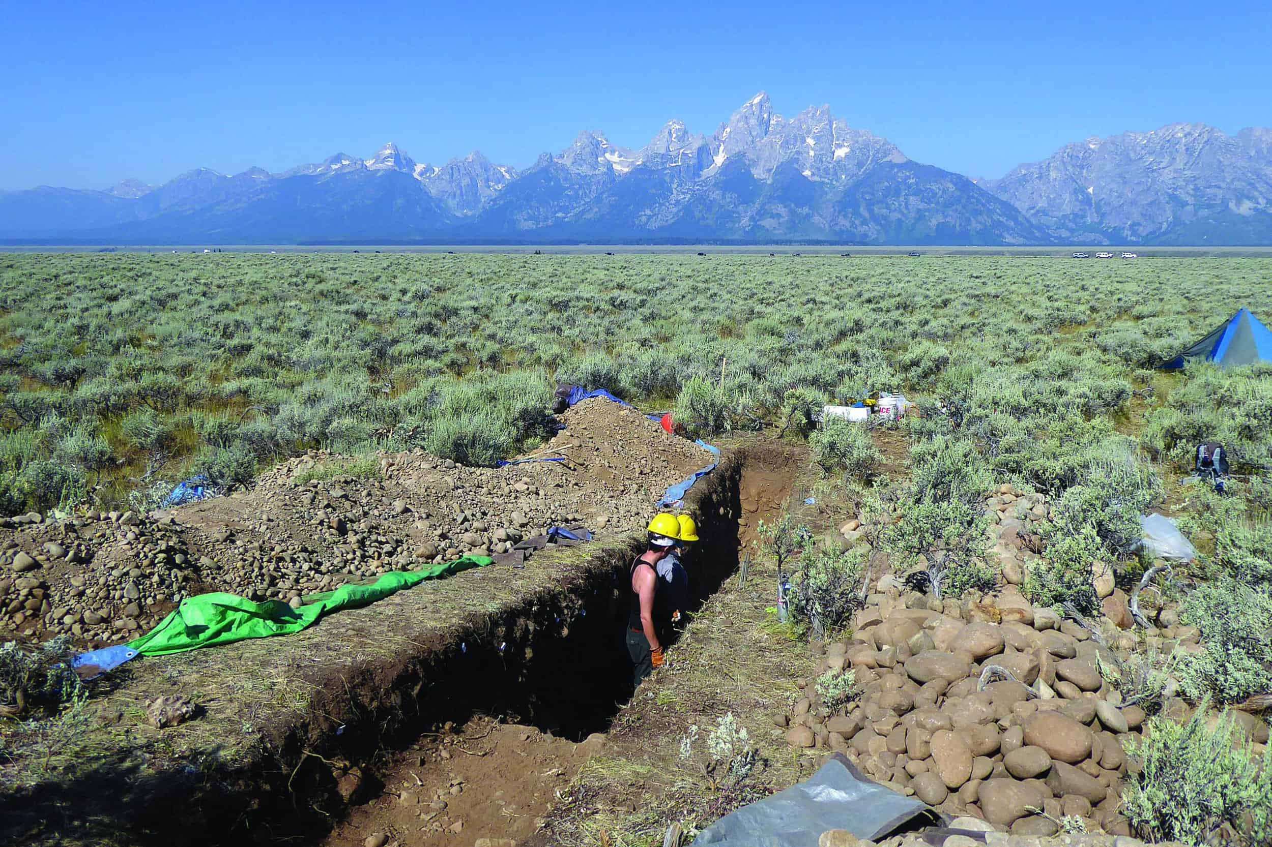
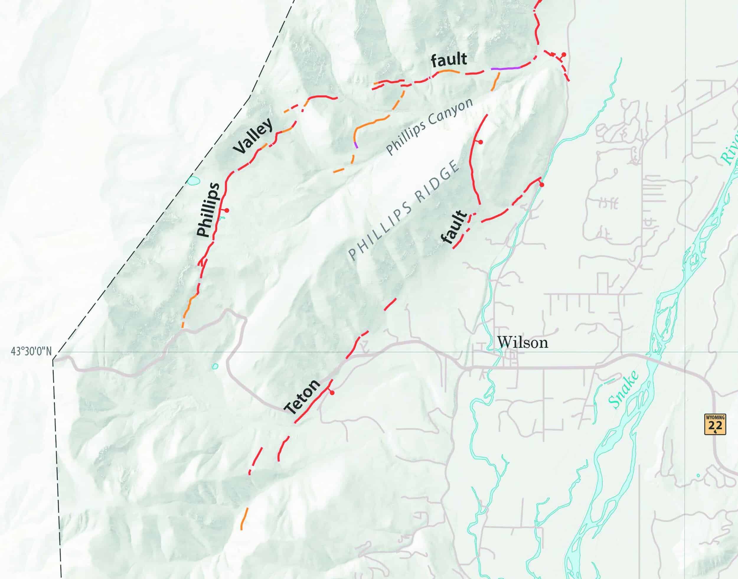
The likelihood of the next earthquake isn’t well understood. In the past few years, geologists have made great strides toward determining the Teton Fault’s scope and its historic earthquake activity, especially in the time since glaciers retreated 15,000 years ago. Its location, for starters, has now been mapped with great precision, building off of University of Utah geophysicist Bob Smith’s work. In places the fault is obvious: From the Cathedral Group turnout off Jenny Lake Road, for example, the fault appears as a short, steep hillside running for hundreds of yards at the base of Rockchuck Peak. Other places it’s tougher to detect. Many of the more obscure stretches were delineated in 2015, when Grand Teton National Park (GTNP) had a plane fly over using a laser-beam technology called “light detection and ranging,” or LiDAR. The flight and subsequent excavations on the ground picked up some newfound sections of the fault, including its southernmost reaches, where it bisects Old Pass Road just a couple hundred yards uphill of the trailhead at the bottom.
In 2019 DuRoss and others excavated the fault here, conducting a paleoseismic investigation not far from Wilson. Similar subterranean assessments that make use of trenches have been executed at Leigh Lake, Steamboat Mountain, Antelope Flats, and at Jackson Hole Mountain Resort, all in the past few years. Data gathered from these investigations proved that the most recent major earthquake, 5,300 years ago, was a magnitude 7.1 that displaced the Teton Fault by five and a half feet and broke the surface of the entire forty-five fault miles that have been mapped to date. That means what it sounds like—the earth opened up, as a result of movement at the fault that expresses itself violently.
While digging into the dry earth is a tried-and-true method to decipher a fault’s seismic history, looking for underwater evidence is further sharpening the picture of the Teton Fault’s past. Paleoclimatologist and Occidental College professor Darren Larsen has spent days out in the middle of Jenny Lake extracting sediment with coring devices that bore down fifteen feet beneath the lakebed. He found many distinct layers of debris that sloughed off the Tetons while they shook violently thousands and thousands of years ago. This deposited material is well out into the lake, far beyond where silt and sand flow in from Cascade and Hanging Canyons and the String Lake channel. “It’s almost a mile from the inflows,” Larsen says. “It’s really just finer silts and clays that get deposited out there [in usual times], so to find coarse sand out in the middle of the lake, immediately we recognized something unusual must have happened here. This was an event.” Nine events, to be precise. That’s a revelation, because prior dry-land excavations had only found evidence of three earthquakes. The telltale sand layers signifying an earthquake, which are called “turbidite,” ranged from less than inch thick (estimated 5,326 years ago) to fifteen inches thick (14,062 years ago). Those dates are relatively precise—accurate to within a century or so—because they’re based on organic material that’s preserved within the sand layers. “What’s exiting about the lakes is we can go further back in time,” Larsen says. “And one of the interesting features that’s coming out of this work is that the frequency of these earthquakes has not been constant.”
The sediment data assembled suggests the Teton Fault went big with relative regularity shortly after glaciers receded from Jackson Hole’s valley floor, around 15,000 years ago. Quakes struck every 500 to 1,300 years or so, up until 7,700 years ago; there’s only been one since. “The conventional wisdom is that the next big quake is overdue,” Smith wrote in the book Windows into the Earth: The Geologic Story of Yellowstone and Grand Teton National Parks. The jury is still out on why the fault has slowed down significantly, though a leading theory is that the melting of the glacial ice, which removed a tremendous amount of weight, somehow sparked a long period of more-frequent ruptures. One limitation about using lake sediments to read a fault’s seismic history is that it says little about the earthquake’s size. A workaround, however, is to check other lakes—like Phelps, Taggart, Bradley, and Leigh—to try to find sedimentary evidence of the same seismic activity, and Larsen has done just that. “It seems that most of the major earthquakes at Jenny Lake, if not all of them, are actually replicated in each of these other lakes,” Larsen says. “That suggests that these events are the results of major ruptures along the entire fault, so very large earthquakes.”
“The last caldera-forming eruption in Yellowstone was 600,000 years ago, and the one before that was 1.2 million years ago. The Teton Fault, on the other hand, in the last 10,000 years, has generated three major earthquakes. In the last 15,000 years, likely six earthquakes.”
—Chris DuRoss, U.S. Geological Survey Research Geologist
The flood of new data being amassed about the Teton Fault is useful partly because it provides insight into the danger it poses. The short of it: The forty-five-mile-long fault that gave Jackson Hole the Tetons and a national park that draws millions of visitors a year is among the most hazardous faults in the entire Rocky Mountains. That judgement is based on its potential to produce a magnitude seven or greater quake, which could claim lives. But it also takes into account the probability of another rupture, after five millennia of seismic peace. “Earthquake prediction is not possible right now,” DuRoss says. “Let’s say if the Teton Fault was perfectly periodic, it might have an earthquake every 2,500 years. But it’s not. And the reason why it’s not is complicated. Trying to predict a future earthquake for a system that you don’t fully understand is a fool’s errand.”
But DuRoss’s employer, the U.S. Geological Survey, does crunch seismic data to come up with earthquake forecasts for known hazardous faults, like the Wasatch Fault just east of Salt Lake City, which threatens a much larger population center. After seven years of planning and meetings and modeling, the federal agency in 2016 forecasted there was a 43 percent chance of it producing a magnitude 6.75 or greater earthquake in the next fifty years. “To do this for the Teton Fault would be really interesting,” DuRoss says. “In the past, we haven’t had enough data to do it. But now I think we probably do. I’m not going to commit the USGS to anything, but it is certainly something that is of interest to me.”
Thigpen’s examination into the idea of a longer Teton Fault—erased to the north by the Yellowstone caldera—is also on the horizon. The unproven theory hasn’t yet been accepted into peer-reviewed journals and is “conjecture, at this point,” DuRoss says. The University of Kentucky professor says he knows that doubters are many, though he remains eager to dig up the evidence he needs. “We got a big National Science Foundation grant to continue this work,” Thigpen says. Leading a big field crew, he’ll be back this summer, coring sediment under Jackson Lake, looking for geologic evidence of Teton-like mountains farther north and, in the lab, building a mechanical thermal model to illustrate what could have happened. If he’s able to prove the theory, it’ll upend conventional beliefs of the Tetons’ deepest history. “Geology likes to make incremental steps forward and does not like big leaps,” Thigpen says. “I agree, maybe this is a totally absurd idea. That’s what makes it kind of fun for us.”
WHAT AN EARTHQUAKE FROM THE TETON FAULT MIGHT LOOK LIKE
Because there are no creeping movements or small temblors to ease the pressure buildup at the Teton Fault, when it goes, it will very likely go big. Geophysicists like University of Utah emeritus professor Bob Smith have dug into the fault before, including in 1992 when he excavated in the Granite Canyon area near GTNP’s southern boundary. At the time, Smith and his research team found evidence of two historic earthquakes, including the most recent one an estimated 5,300 years ago that produced an estimated 5.5 feet of vertical ground movement. This corresponds roughly to a 7.1 magnitude event. With the current development and population of Jackson Hole, USGS research geologist DuRoss says there would be a lot of damage to buildings, pipelines, and roads. “Grand Teton National Park would probably take the brunt of it,” he says.
Smith, a Jackson Hole resident, painted a picture of what would likely happen in a book he co-authored, Windows into the Earth. “Landslides along the front of the Teton Range send huge clouds of dust skyward,” he wrote. “Slides in the Gros Ventre, Hoback, and Snake River Canyons block roads. Avalanches and rockfalls plunge off high Teton peaks, entombing a few scattered groups of mountaineers asleep in their tent.” The human death toll could reach dozens, he wrote in the hypothetical narrative, and the infrastructure toll could be staggering. The Jackson Lake Dam was fortified in the 1980s so that it could withstand a 7.5 magnitude jolt, but if there were a breach, a slow-moving flood would move down the Snake River corridor. This roaring torrent would take seventeen hours to reach Palisades Reservoir, but along the way it would devastate low-lying areas, especially near Moose and Wilson. JH