Read The
Current Issue
Valley to Valley
Ski touring, like other forms of mountain adventuring, can be an exciting way of seeing and connecting new and old places—just plan carefully and know your level of risk.
By Mike Koshmrl // photography by ryan dorgan
AT ABOUT 6,500 feet in elevation, winter regains its hold on the landscape, and the patchy, semi-graveled snowmobile track climbing out of Mosquito Creek south of the community of Wilson transitions back to pure snow.
It’s well into April, and in the valley’s lowest elevations spring has set in. It’s one of those first brilliant sunny days that feels of the big melt and warmth to come, though at 7 a.m. the air is crisp and the snowpack bulletproof from last night’s freeze. We leave our skis on our backs, knowing that walking on top of the crust will be easier than skiing, also known as “skinning,” up the icy surface, which undulates due to the rivulets of melt that have run over and through the snow-packed road surface in weeks prior. We kick steps up, pointed southwest into the heart of the Snake River Range’s Palisades Wilderness Study Area.
Photographer and adventure buddy Ryan Dorgan accompanies me, along with our dogs, Dottie and Sota. Our objective is to connect Jackson Hole to Palisades Reservoir, in the northern part of Star Valley. Initially, we planned to take off from Teton Pass, drop into Mosquito Creek, and then camp for a night, but a forecasted snowstorm during our initial window for this adventure put the kibosh on that plan. Fast forward a couple of weeks and it’s later in the year than planned—thus the true spring ski tour that’s underway.
Vetting a route, I called up guide and author Tom Turiano, who knows the lay of the Snake River Range and the region’s seldom-seen mountains about as well as anyone. (For a guidebook on more ski lines and tours than you’ll ever be able to manage, check out his 2014 book, Jackson Hole Backcountry Skier’s Guide: South.) My initial instinct was to take the path of least resistance. There’s actually a crude road, which, in winter, transforms into a snowmobile trail that climbs to a 7,580-foot divide between Mosquito and Big Elk Creeks. Just climb this road, I figured, drop into the next drainage, ski and skin the dozen miles to the Big Elk trailhead at the end of a finger spurring off Palisades, and … voila, done.
Turiano’s advice was that we should abandon that route though. It is not a hazardous or bad way, but, according to him, it’s boring. It is down in a canyon most of the way and, even when the snow is good, doesn’t offer many opportunities for nice skiing. But Ryan and I were cramped on time and doubtful of our ability to safely tackle something bigger, so we opted for boring—except it turned out not to be boring for us.
Our objective is to connect Jackson Hole to Palisades Reservoir, in the northern part of Star Valley.
THREE HOURS IN, we’re at the Mosquito-Big Elk Divide, and everything’s absolutely dandy. The snow stayed solid into the late morning hours, and on the trek up we saw a couple of moose, tracks from mountain lion and black bear, and even a wolf turd. The trumpeting of sandhill cranes flying low interrupt the stillness and quiet, as do the alarm calls of Uinta ground squirrels, aka chiselers—a true sign of spring. Breaking on the pass, we peer east, and admire Gros and Cache Peaks, which dominate the skyline on the eastern side of Jackson Hole.
Part of the allure of this trip is that it connects two places I know well via a middle ground foreign to me. Drawing up and executing these types of connections, with various modes of recreation to choose from, is part of what makes living in a wild, varied, and vast place like Jackson Hole so redeeming. For me, it provides a sense of exploration and helps me think about and comprehend parts of the local landscape and broader Greater Yellowstone Ecosystem as a whole. Recreationally, these connections are sometimes straightforward: A hiker, for instance, can take off from the Granite Creek trailhead on the north side of the Hoback Canyon, and, using Bridger-Teton National Forest trails, arrive in the town of Jackson via the Cache Creek drainage in a day’s time. Of course, there are countless more creative and ambitious ways to weave together the different landscapes we love—from mountain biking a loop around the Gros Ventre Range to ski touring through the Teton Wilderness via Two Ocean Pass to Yellowstone Lake. Get old school, pick up a map, and hatch a novel-to-you adventure plan. Highly recommended.
The descent down into the North Fork of Elk Creek starts out equally as serene as reaching the top of the divide. Off to the north towers Smoke Hollow Peak; Powder Peak looms to the south. The Snake River Range, which I’ve flown over in a prop plane courtesy of Bruce Gordon’s EcoFlight, seems relatively tame from afar. Although bustling with hunters and skiers in the fall and winter, this peripheral Jackson Hole range is pretty deserted the rest of the year, especially its most protected lands, which include the 215-square-mile Palisades Wilderness Study Area. Up close and in the thick of it during one of these “off seasons,” the Palisades’ most prominent peaks feel stark and powerful.
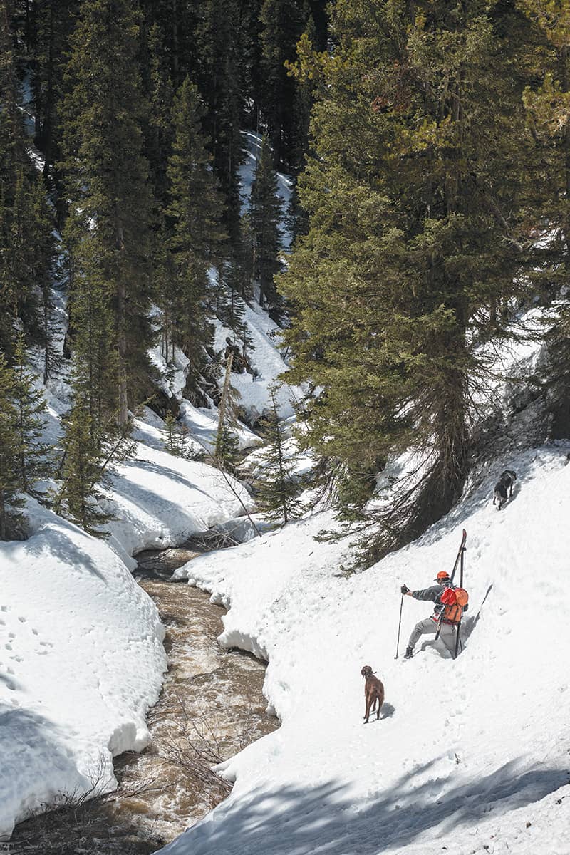
Picking our way down the mountain, the low-angle gulch skiing isn’t great by any measure—like Turiano predicted. But we’re making good time, skirting between groves of conifers and the headwaters of Big Elk Creek, which begins to reveal itself through the still-sizable snowpack just a few hundred vertical feet beneath the divide. In no time, the skiing gets trickier and the exposed stream, fed by fast warming temperatures and melt percolating in from all directions, grows powerful. The very visible snowmobile tracks left behind from the seasons’ powder hounds suddenly peter out. Soon, we see why. The open water cuts into a steep, snow-free canyon where sidehilling on skis (or snowmobiles) is impossible. Our skis go again onto our backs and we scramble around in our boots on talus, boulders, and steep snowfields. It’s rugged, and a dog paw that gets wedged between two rocks presages how the rest of this adventure will go.
“SLOG” AND “MISADVENTURE” are both good words to describe the final six-ish hours of our journey. Since we are soaked anyway, Ryan and I start to wade through the creek with our ski boots on when doing so offers easy passage to skiable snow. At some points, conditions are downright dangerous. The afternoon had grown windy, and while skiing through a timber stand high above the confluence of Big Elk’s north and south forks, a mature tree violently crashes down only a few hundred yards above us. It’s the closest I’ve ever been (and hopefully will ever be) to witnessing potentially lethal deadfall. We pass massive avalanche chutes littered with trees and debris from slides that went big, likely unseen, deep in the Palisades over the winter.
Awaiting us at the finish is a shuttle captained by our gracious girlfriends, who undershot our true arrival time (only because my estimate of how long the traverse would take us was overly ambitious). They waited for us at the Big Elk trailhead for hours.
In planning, I failed to consider that Palisades Reservoir is nearly 1,000 feet lower in elevation than Jackson. The snow thins into soft clumps before almost entirely giving way to a muddy hiking trail. We’re ready to be finished. Our “heads-down, get-there” mentality is a shame though, because the lower reaches of Big Elk Canyon are stunning. Near the Wyoming-Idaho state line, high rock walls straddle both sides of the creek, which here moves serious amounts of water towards Palisades Reservoir and eventually the Snake River. The craggy terrain provides habitat for mountain goats, which are a fairly rare wildlife sighting, yet two of the startled white rock climbers scamper away as we round a bend.
After hiking and skiing about 18 miles over almost 13 hours we finally finish, and once we catch a cell signal it alleviates some anxieties. “We waited at the trailhead for about three hours, and we read and napped,” my girlfriend, Julia, says. “Then, when you guys were really late and we started getting worried, we went to the Mexican restaurant and got margaritas and food.”
They circled back, though, to swoop up dog-tired pups and Ryan and me, now thirsty and pooped with half-broken bodies drenched in sweat and creek water. Still, we eagerly mosey into Alpine’s Bull Moose Saloon for grub and beers. JH

Traverses from the creek bottom up and over cliffs and boulder fields gave sweeping views of the Big Elk drainage and surrounding peaks in the Snake River Range.
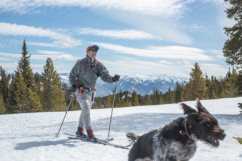
The author looks west toward Powder Peak from the divide between Mosquito and Big Elk Creeks in the Snake River Range.

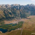
The 18-mile trek from Jackson Hole to Star Valley via Mosquito and Big Elk Creeks brings travelers across the Wyoming/Idaho state line near Palisades Reservoir.