Read The
Current Issue
The Road Less Traveled
Explore the valley’s dirt roads with a Utility Terrain Vehicle.
Story and photography By Dina Mishev
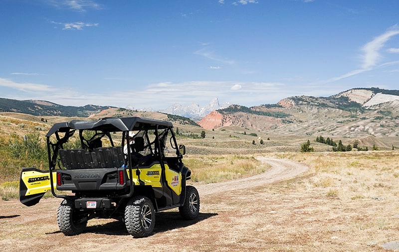
The author and her parents headed up the Gros Ventre Road east of Kelly with a rental Honda Pioneer5 1000 utility terrain vehicle from Jackson Hole Backcountry Rentals, sandwiches from Kelly on the Gros Ventre market, maps, and a plan to explore any of the numerous dirt two-tracks branching off the main road that looked interesting.
MY MOM IS the first to spot the beast in my driveway. Not that it’s hard to see. A human-sized lovechild of a Barbie Jeep and a Transformer, the Honda Pioneer5 1000 is bright yellow, snub nosed, and looks exactly like the vehicle you’d want at the End Times. Such a monster has never before graced my driveway. It’s 8:30 on a bluebird September morning and Jackson Hole Backcountry Rentals is dropping off the side-by-side—aka a Utility Terrain Vehicle (UTV). It is ours for the day. I immediately christen it “Neon Buffalo.”
My plan is to take my parents deep into the Gros Ventre Mountains on the east side of Jackson Hole, where there are rutted, washboarded ribbons of dirt roads that I know from experience my Nissan XTerra SUV does not like. Within the Gros Ventres I don’t have a specific destination picked out. “We’ll go wherever looks the most interesting,” I say, as we rumble away from East Jackson and towards the tiny community of Kelly, about 13 miles on paved roads north and east of town. Not that either of my parents can hear me. The Neon Buffalo is loud.
FORMERLY, LIKE THE first 18 (of 23) years I lived in Jackson Hole, when my mom and dad would make the trip from their home in Maryland to visit, I’d drag them on difficult hikes up mountain passes. They’re athletic, but would never self-identify as hikers. Still, they were always game for whatever hiking adventure I cooked up, even when I’d taken them on enough such adventures that they knew they’d be very, very sore for the rest of their visit. Once I even sent them off on a five-day guided backpacking trip in Yellowstone on which llamas carried all the food and supplies.
This was not payback for grounding me my freshman year of high school after catching me climbing out of my bedroom window to go to a friend’s party. I did this so they could get a taste of why I love Jackson Hole and the surrounding mountains so much. I didn’t take them hiking to take them hiking, but because hiking was the easiest way to get to the remote, sprawling vistas that were among the reasons I decided not just to be a ski bum in Jackson Hole, but to build my adult life here.
But now I’ve got arthritis in one knee and my parents are 76 and 83. So, enter the Neon Buffalo. In most ways—like noise, obtrusiveness, speed, and presence on the landscape—UTVing is the polar opposite of hiking. But now that UTVs are available to rent locally, they offer the easiest way to get to some of the remote mountain vistas I love so much, and even discover new ones. ABOUT ONE HOUR and twenty(ish) miles of washboarded dirt east of Kelly, shortly after driving over a bridge across the Gros Ventre River, and just as I’m getting impatient at the dearth of interesting two-tracks off the main road, we come upon a junction. Small, wood signs sticking out of the sage flats indicate Gunsight Pass is seven miles in one direction and the Cottonwood Creek Trailhead six miles in another. Purposefully not looking at the topo maps I downloaded onto my phone at home that morning—I’m looking to explore, after all; the maps are only in case I get us lost—I turn the Neon Buffalo onto the path to Gunsight Pass.
We literally have an eagle’s-eye view of the Gros Ventre River Valley where our climb began: as we unpack the sandwiches we bought at Kelly’s lone retail establishment, Kelly on the Gros Ventre, an eagle flies overhead.
In less than a mile, for the first time that day we’re finally on a road that would be challenging, or at least very slow going, in an SUV or truck. The Neon Buffalo eats it up though, progressing blissfully and easily, slowed by neither potholes nor deep ruts. I couldn’t be happier, but dust forces me to temper my smiling. (Part of the appeal of a UTV is that it doesn’t have windows, but no windows can mean a mouthful of grit if you open your mouth at an inopportune time.)
About 600 vertical feet above the junction, I slow the Neon Buffalo after coming around a switchback to face a 100-foot section of loose, smooth, softball-sized river rocks. An SUV or truck could so easily sink into something like this and get stuck. But we’re not in an SUV or truck. The Neon Buffalo makes easy work of it and then gets back to climbing. And climbing. And climbing. Somewhere around 9,000 feet above sea level I drive into a dragonfly, which, because there is no front window, bounces off my right shoulder before flitting around the Neon Buffalo’s interior. After checking out my parents in the front and rear seats, it exits out the passenger side seemingly no worse for the wear.
By the time the track finally peters out, we’ve climbed more than 2,000 vertical feet to the high point of a gentle ridge. We’re at an elevation—about 9,700 feet—higher than I was ever able to get to with my parents via hiking.
We literally have an eagle’s-eye view of the Gros Ventre River Valley where our climb began: As we unpack the sandwiches we bought at Kelly’s lone retail establishment, Kelly on the Gros Ventre, an eagle flies overhead. The Tetons aren’t visible, but in the opposite direction the long, snaggly spine and glaciers of the Wind River Range are. Gannett Peak, that range’s, and Wyoming’s, tallest mountain (13,810 feet above sea level) is easily identifiable. So is Sheep Mountain, aka Sleeping Indian, one of the most prominent peaks in the Gros Ventres seen from Jackson Hole (although from this perspective it looks more like an impregnable fortress than a sleeping Indian). Other Gros Ventre mountains we spot include Black Peak and Mt. Leidy. To the north we can see the Absaroka Range, its telltale pinnacles and spires craggy even from this distance. We see no other people or UTVs.
“I feel like we’re in the middle of nowhere,” says my mom. “And we’re not going to be sore tomorrow. We might still be dusty, but we won’t be sore.” JH
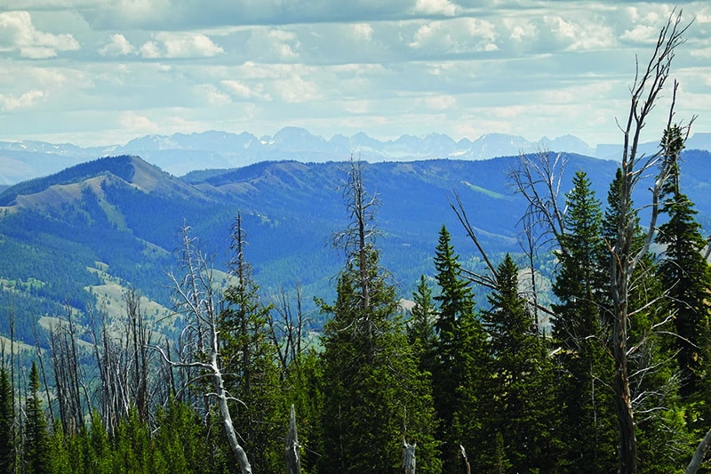
From the top of Gunsight Pass, about 9,700 feet in elevation, the Wind River Mountains, the largest and most glaciated range in the state of Wyoming, are visible to the east.

The author’s parents enjoy a picnic lunch and views from the top of Gunsight Pass.