Read The
Current Issue

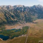
Head for the Skyline
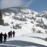
A new hiking and biking trail just above town offers views of at least four mountain ranges. You may also see wildflowers and wildlife.
By Brigid Mander
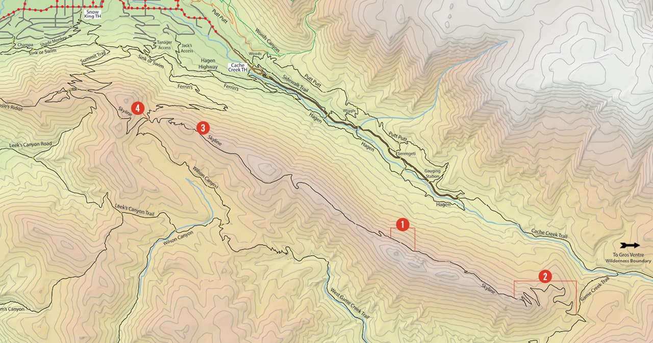
IT TOOK FIVE years from proposal to people pedaling on the Skyline Trail, but building a new mountain biking/running/hiking trail on U.S. Forest Service (USFS) land is never an easy project. It could be argued that the backbreaking manual labor is the easiest part of it. Before the first pick hit the dirt for the Skyline Trail, four years had been spent mapping it out, studying wildlife usage of the area, securing permits, getting public comments, reacting to public comments, and raising money. In the Bridger-Teton National Forest (BTNF), the trail runs 6.3 miles along the undulating ridgeline that stretches from the top of the Ferrins trail east of the summit of Snow King to the Cache-Game Divide. It opened late last August. Local groups raised about $145,000 to fund the trail’s construction, and riders, hikers, and runners donated countless hours of their time to make it a reality.
Best Scenic Lookouts (#1). This whole trail is beautiful—expect grassy alpine meadows (maybe even covered in wildflowers), thick old-growth forest, rock outcrops, aspen groves, and mountains everywhere. But some spots are stunning. If you’re heading east (from Snow King/Ferrins toward Game), when you gain the fourth “peak,” pause at an open, flat section for spectacular Teton views. From the other direction, immediately after you gain the ridge, a small spur trail leads into a clearing with views of the Tetons and Gros Ventres.
Most Technical Section (#2). The first 1.5 miles from the east climbs up from the Cache-Game Creek saddle. Gaining about 800 feet as it switchbacks up a steep, rocky slope, it can be brutal, whether on bike or foot. Instead of dwelling on how much it might be testing your legs, think instead of the fact that this was the only section of trail built using machinery. (Digging it by hand would have taken nearly two more years). When descending this section on your bike, be sure to keep your speed in check.
Best Lunch Spot (#3). Heading east on the trail from Ferrins, as you gain the first peak, look for a spur footpath to the south. Follow it for about 25 feet to a flat rock in a sunny, open area with views down into Game Creek and of the Tetons. For those who don’t want to hike the full trail, it’s an ideal objective. For everyone, it’s an ideal picnic spot.
Most Unusual Marker (#4). The USFS has a policy of not naming trails after individuals. However, in the case of the Skyline Trail, officials were amenable to a plaque commemorating Luke Lynch, whose time and work were integral to the trail becoming a reality. A few days after final approval for the project in 2015, Lynch died in an avalanche in the Tetons. A plaque honoring him is located at the Ferrins saddle on the west end of the trail. Lynch, a board member of Friends of Pathways and the Wyoming director of The Conservation Fund, was inspired to build the trail to honor his brother, Matt, who died in a cycling accident in Chicago in 2008.
The Work Behind the Trail. Linda Merigliano, the BTNF wilderness and recreation program manager, requested community involvement in creating the Skyline Trail and she got it. Volunteers built the first 1.5 miles leading east from Ferrins in two days. Next, a mix of volunteers and BTNF trail crew continued building the trail east. Eventually, too much of their day was spent hiking along the ridge to get to the construction area. So for six weeks last summer, Montana Conservation Corps trailbuilders camped along the trail, and local volunteers hiked supplies up to them.