Read The
Current Issue

6 Favorite Yellowstone Hikes
Our local national park has something for every kind of hiker.
// By Dina Mishev
Many of Yellowstone’s best-known attractions, whether of the geothermal or wildlife variety, can be seen from a car or via a short walk. Still, hiking in the 2.2-million-acre park—which has more than 250 trails that together offer 1,000-plus miles of hiking—shouldn’t be missed. Here are six of our favorites, each of which offers a quintessentially Yellowstone experience.
1. A Forest Loop with Lake Views
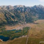
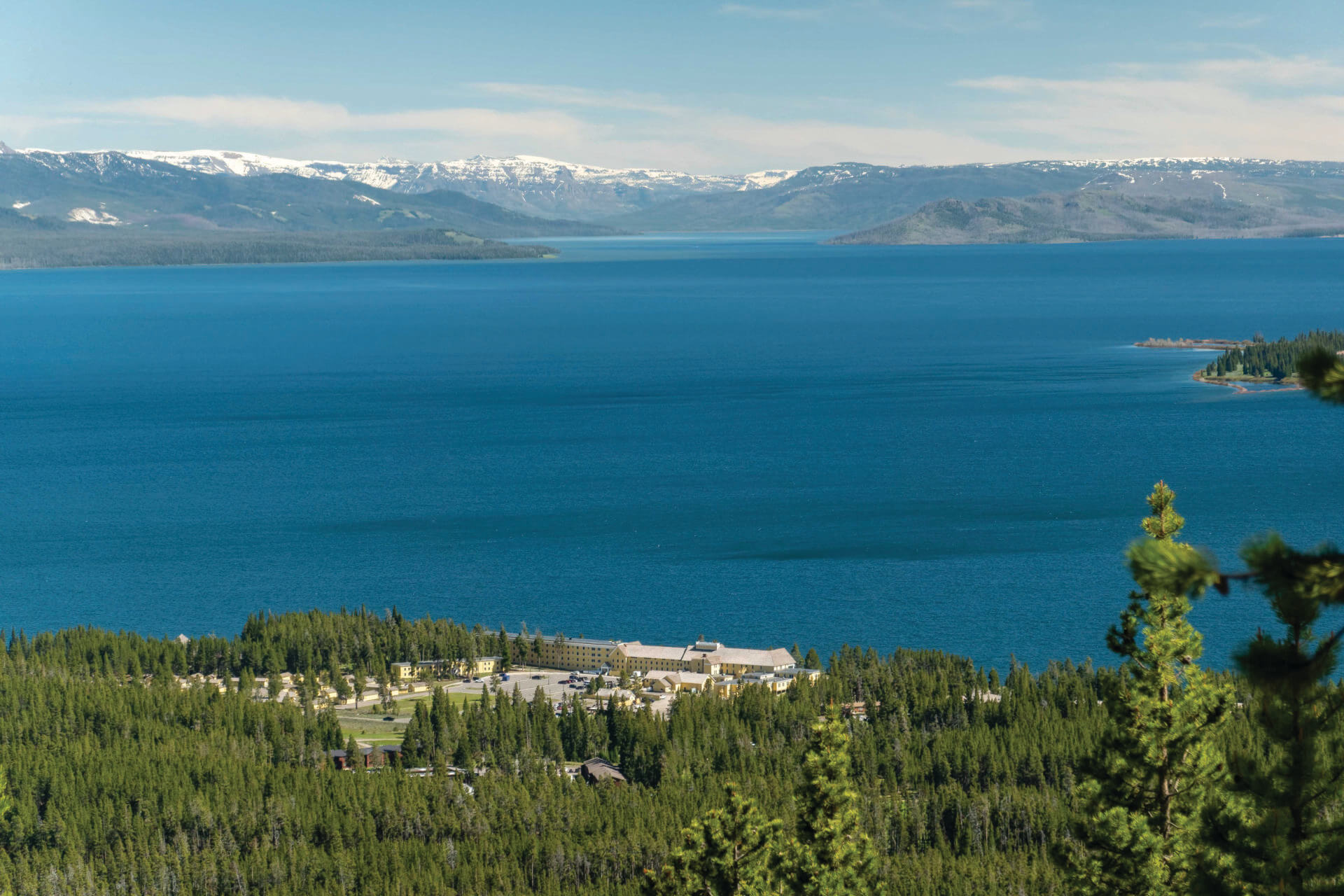
TheElephant Back Mountain Trail, with its views of Yellowstone Lake, has been popular with park visitors since it was constructed in 1928. Today, the trail is one of the park’s highest priorities in terms of maintenance, so it’s almost always in great shape. Its location between Fishing Bridge and Lake Hotel means that it is also well-traveled, which might ease the minds of visitors nervous about heading into the wild.
The trail is a lollipop—the first and last several hundred yards form the “stick,” and the remainder is a loop that gently switchbacks about 800 feet up to a lookout on Elephant Back Mountain, which was named by the 1871 Hayden Expedition. The loop can be done in either direction, but the slope is less steep on the eastern side. (If you want a more gradual ascent, do the loop counterclockwise; if you want a more gradual descent, go clockwise.)
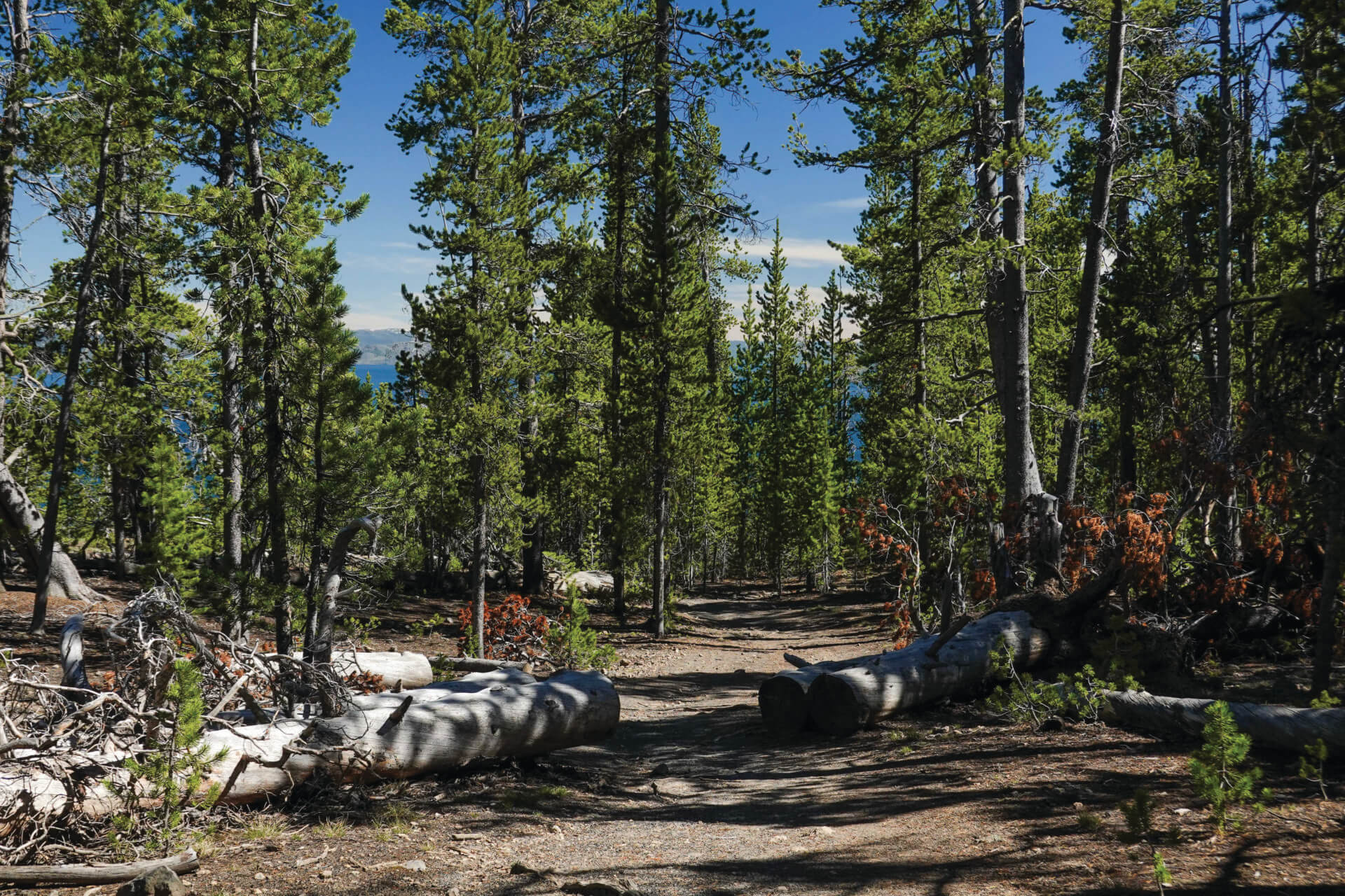
While much of this area of the park burned in the fires of 1988, the flames spared this trail, so you’re walking through a mature lodgepole pine forest up to the lookout. As the trail climbs, you’ll get periodic views through the forest to Yellowstone Lake. Go ahead and stop to enjoy these (and catch your breath), but know that the lookout at the top of the loop has the best views.
Yellowstone Lake dominates the view from the top, but a man-made structure, the Lake Hotel, is worth considering, too. Opened in 1891, the hotel is the oldest lodge in Yellowstone and in any U.S. national park. Designated a National Historic Landmark in 2015, its butter-yellow colonial revival-style exterior is hard to miss.
Details: Four‑mile lollipop with 800 feet of elevation gain and loss.
Best for: Visitors looking to experience Yellowstone a little more deeply than viewpoints and pull-outs allow without venturing too far from other people.
What to know: Although this is a busy trail, bear encounters are possible; always carry bear spray and know how to use it.
Also in the area: The Lake String Quartet plays free concerts five nights a week in July and August at the Lake Hotel.
Find it: The trailhead is about .7 mile south of Fishing Bridge; parking areas are on both sides of the road.
2. A Waterfall and Canyon
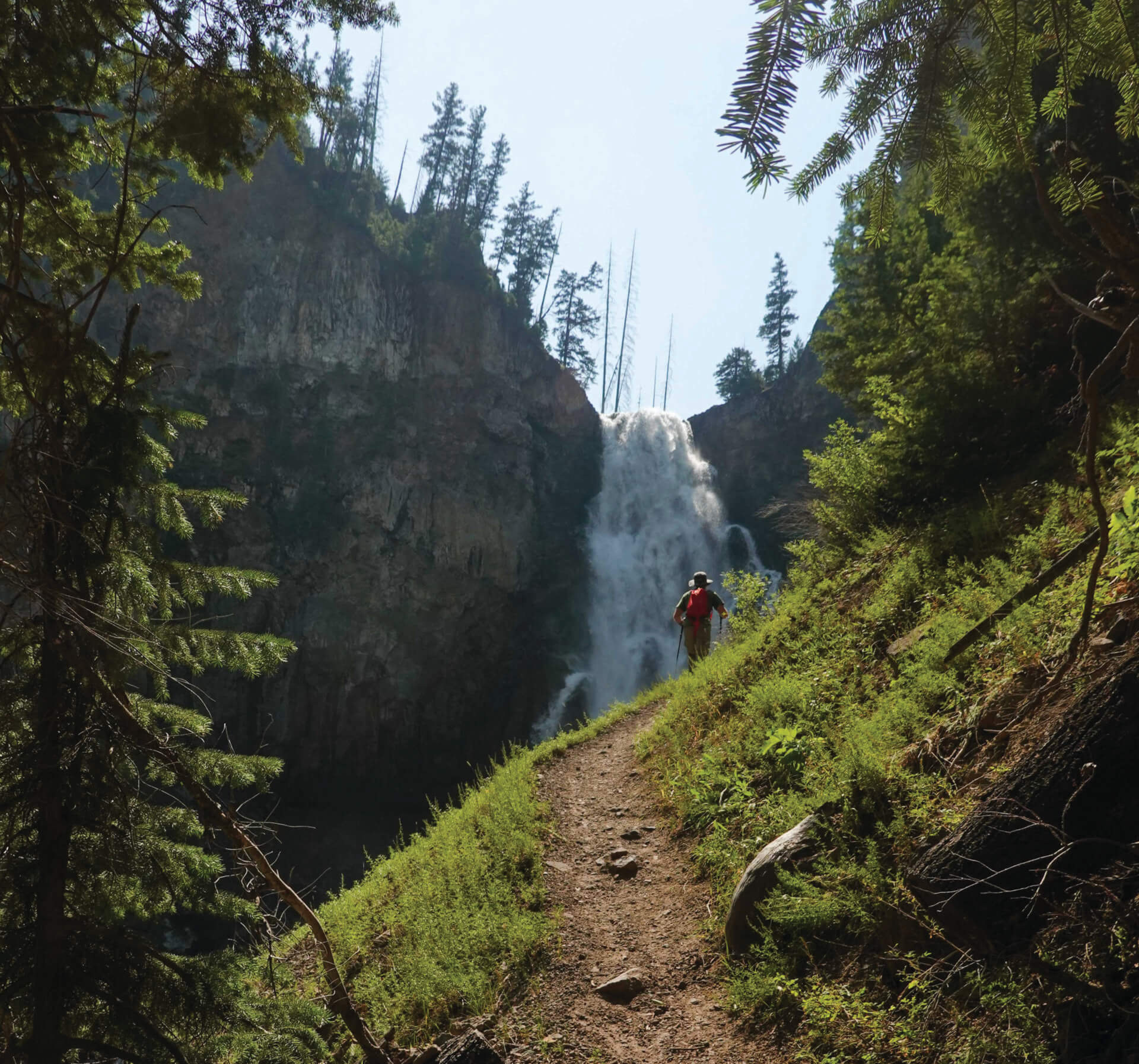
Just south of Mammoth Hot Springs, famous for its alien-looking mineral terraces, is a trail into the second-deepest canyon in the park. The trail ends at the base of the 150-foot-tall Osprey Falls.
The first three miles of this hike are flat on a former carriage road. Then you encounter a fork and this sign: “Caution trail is steep and narrow. Travel at your own risk.” From this point, it’s 800 vertical feet down into Sheepeater Canyon on a trail that is indeed steep and narrow, and sometimes also exposed. But, even if Osprey Falls wasn’t waiting at the end of the trail, the hike down into the dramatic Sheepeater Canyon is worth it for sure-footed hikers.
But Osprey Falls, about the ninth-tallest plunge waterfall in the park, does wait at the end of the trail. The last time I did this hike, my friend and I had the falls, which you can hear well before you see, all to ourselves. We spent 30 minutes enjoying a picnic lunch on flat rocks about 100 feet below the bottom of the falls.
Details: Nine‑mile out-and-back hike with 800 feet of elevation loss and gain.
Best for: Waterfall seekers unafraid of heights (the last mile of the trail is down a steep hillside).
What to know: If you’re in Yellowstone with a bike, you can ride the three miles from the trailhead to where the Osprey Falls trail forks off from the former carriage road. Bicycles are not allowed in Sheepeater Canyon.
Also in the area: Link the hike to Osprey Falls with a hike to the 8,564-foot-tall summit of Bunsen Peak in an 11-mile lollipop loop.
Find it: The Bunsen Peak/Osprey Falls trailhead is five miles south of Mammoth Hot Springs.
3. Historic Fire Lookout
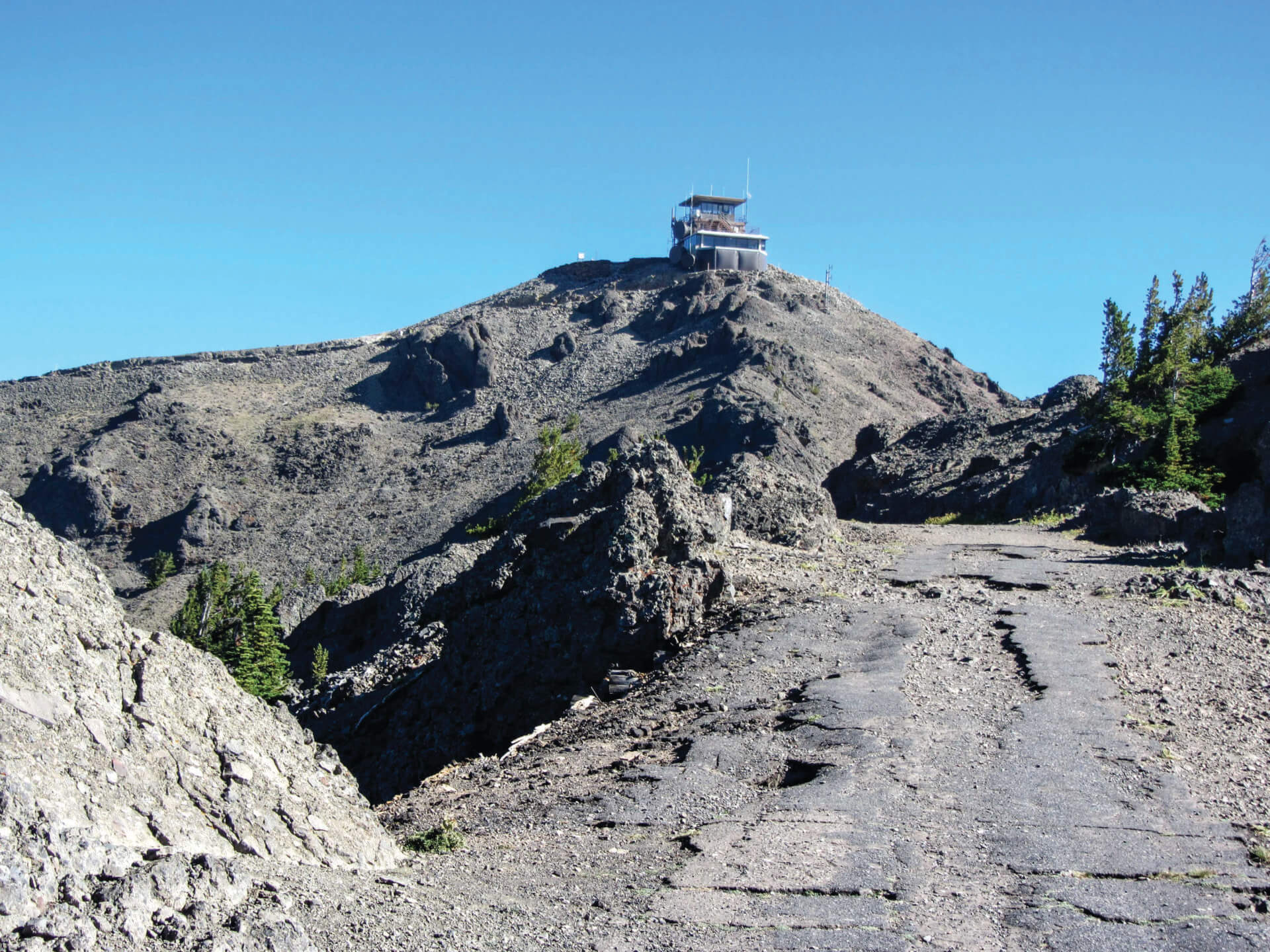
A remnant of an extinct volcano, Mt. Washburn was literally cut in half by an eruption 631,000 years ago. Hiking to its 10,219-foot summit is one of the most popular day hikes in Yellowstone. Along the way, expect to see bighorn sheep, whitebark pine trees, and more than 50 species of wildflowers. From the summit on a clear day, views stretch for 20 to 50 miles and include the Tetons, the Grand Canyon of the Yellowstone, Yellowstone Lake, and Mt. Holmes, the tallest mountain in the Wyoming portion of the Gallatin Range.
An additional summit sight is one of only three active fire lookouts in Yellowstone. The current fire lookout was built between 1939 and 1941 as part of the New Deal. It replaced a 1921 lookout on the same site. Constructed of reinforced concrete, its design, which includes Art Deco elements, was a shift from the rustic architecture of the time that favored native stone and log. Today it is continuously staffed by firefighters from mid-June until the fire season ends.
There are two trails to Washburn’s summit, the Mt. Washburn South Trail and Chittenden Road-Mt. Washburn Trail. Both trails have about the same elevation gain and loss—1,400 feet—but the south trail is slightly longer (about 6.5 miles round-trip), which makes it the less-steep option. The round-trip hike starting at Chittenden Road is about 4.5 miles. Both trails follow former roads and are wide paths. The Chittenden Road trail does not have any switchbacks or shade; the south trail switchbacks up through meadows and whitebark pine forest. Bicycles are allowed on the Chittenden Road trail.
Details: About six miles round trip with approximately 1,400 feet of elevation gain and loss.
Best for: Hikers interested in fire lookouts and summit seekers who want the comfort of crowds.
What to know: Grizzly bears frequent the area in the fall in search of whitebark pine nuts; carrying bear spray is a must, and it’s recommended to hike in groups of three or more people.
Also in the area: Hitting 8,859 feet above sea level, Dunraven Pass is the highest road in Yellowstone and offers easy stargazing if you don’t
mind driving a mountain road at night.
Find it: The Mt. Washburn South Trailhead is at the top of Dunraven Pass, five miles north of Canyon Village; the Chittenden Road Trailhead is an additional five miles north and then 1.2 miles down a spur road.
4. Hike to a Summit
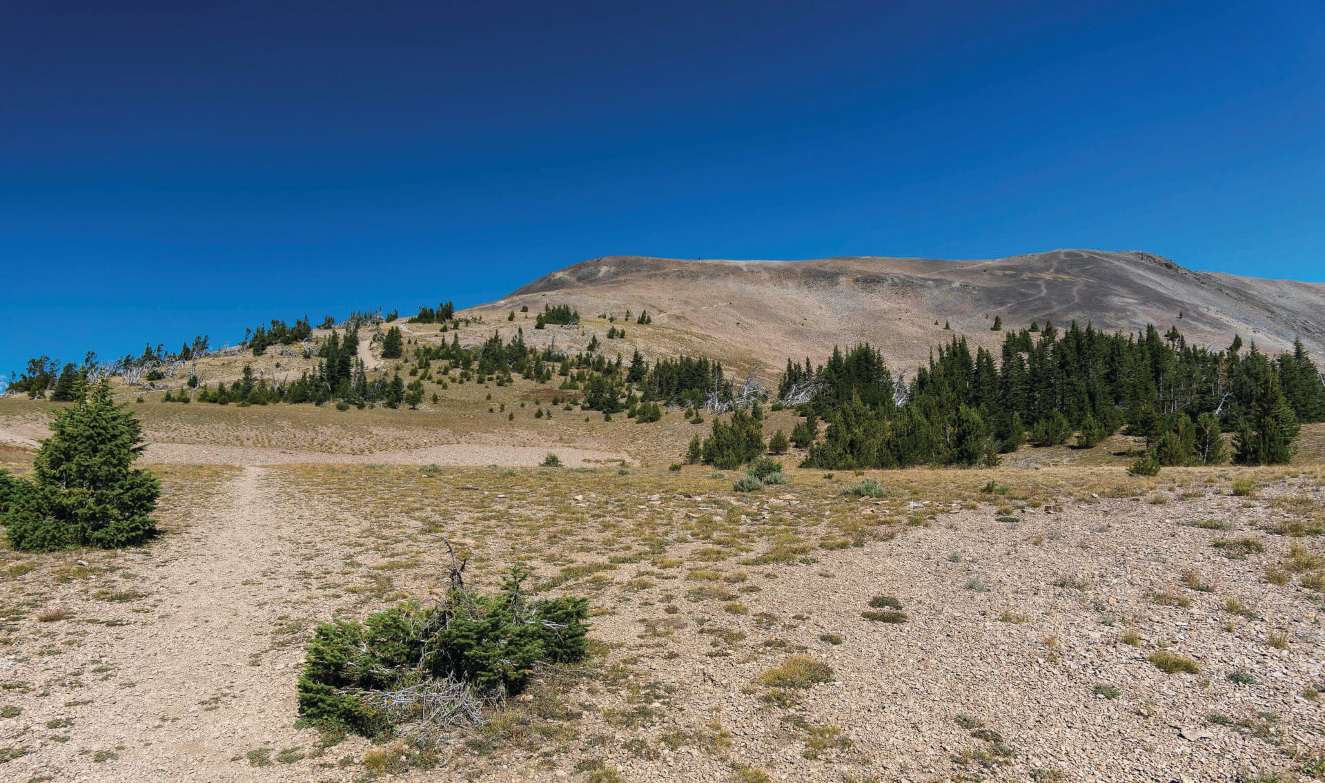
Avalanche Peak is the tallest Yellowstone summit that can be reached via hiking on a maintained (albeit steep and sustained) trail. From the peak’s 10,574-foot-tall summit, you can see the Teton, Absaroka, Beartooth, Madison, and Gallatin mountains, and also Yellowstone Lake.
The climbing begins as soon as you cross the East Entrance Road from the trailhead parking lot and does not stop until you’re on the summit. Thankfully, the bottom half of the trail is heavily forested, protecting you from the scorching high-altitude sun. But few trees grow above 9,600 feet in Yellowstone, and once you’re at this elevation, you still have almost another 1,000 feet of ascent to go.
Once you’ve made it this high, though, you get your first great views of Yellowstone Lake, the largest freshwater lake above 7,000 feet in North America. Twenty miles long and fourteen miles wide (making it about 136 square miles), it has about 140 miles of shoreline. While this size is hard to comprehend from the lake’s shore, it punches you in the face from the summit of Avalanche Peak. The lake covers most of the foreground. It has islands in it! Return to the trailhead the same way you hiked up.
Details: 4.2 mile round-trip out-and-back with 2,100 feet of elevation gain and loss.
Best for: Fit hikers who are comfortable on steep, loose trails.
What to know: This is known grizzly country. Also, the trailhead is at about 8,400 feet; to lower the chances you’ll get altitude sickness, do not attempt this hike until you are acclimated to Jackson Hole’s elevation.
Also in the area: One mile west, the Sylvan Lake Picnic Area has six tables and a restroom. The lake is usually still and offers the opportunity to get photos of Top Notch Peak and its reflection.
Find it: The trail up to Avalanche Peak’s summit starts just across the East Entrance Road from Eleanor Lake, which is just to the west of the top of Sylvan Pass.
5. A Little-Visited Geyser Basin
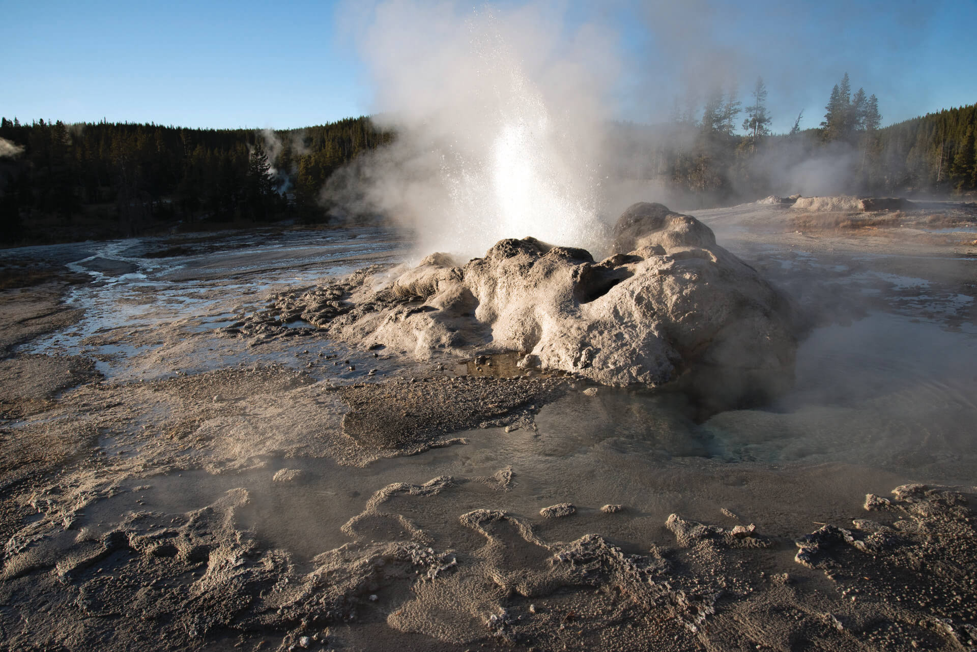
Located on the southwest side of Shoshone Lake, the Shoshone Geyser Basin has one of the highest concentrations of geysers in the world—more than 80 in less than 30 acres. (For comparison’s sake, 30 acres are equal to about 23 football fields, including end zones.) But you have to work to get here; the basin is only accessible by foot or canoe, and the foot version is a 22-mile round-trip hike. But, while it’s long, it is fairly flat.
While the distance to Shoshone Geyser Basin keeps crowds away, the first two miles of the hike are very crowded. But 99 percent of people stop once they reach Lone Star Geyser, which erupts up to 45 feet approximately every three hours. Past here, pick up the Shoshone Lake Trail, which stays close to the Firehole River.
After leaving the river, the trail heads into a lodgepole pine forest and through Shoshone Meadows, which can be boggy, and eventually drops down into the geyser basin, which does not have the safety boardwalks that frontcountry thermal areas do. In 1988, a hiker fell into a geyser here and died from the resulting burns, so be careful.
This basin’s main attraction is Minute Man Geyser. It’s not the tallest geyser in the area, but it spouts every one to three minutes. Taurus Geyser has erupted in the past, but today this deep blue pool with edges lined by orange-colored cyanobacteria and algae mostly just boils and splashes. Still, its contrasting colors are gorgeous. As you explore the basin, see if you notice any general differences between the east and west sides. Geysers on the eastern side of the basin are predominantly acidic, while those on the western side are almost entirely alkaline.
Details: About 22 miles round trip with about 1,500 vertical feet of ascent/descent.
Best for: Geyser gazers eager to experience the park’s thermal wonders as early explorers did.
What to know: This can be a long day-hike or a backpacking trip; overnight permits are required.
Also in the area: Shoshone Lake is the second-largest lake in Yellowstone and is believed to be the largest backcountry lake in the Lower 48 States.
Find it: The Lone Star Geyser Trailhead is 3.5 miles south of Old Faithful Overpass, just beyond Kepler Cascades Parking Lot.
6. A Challenging Ridgeline
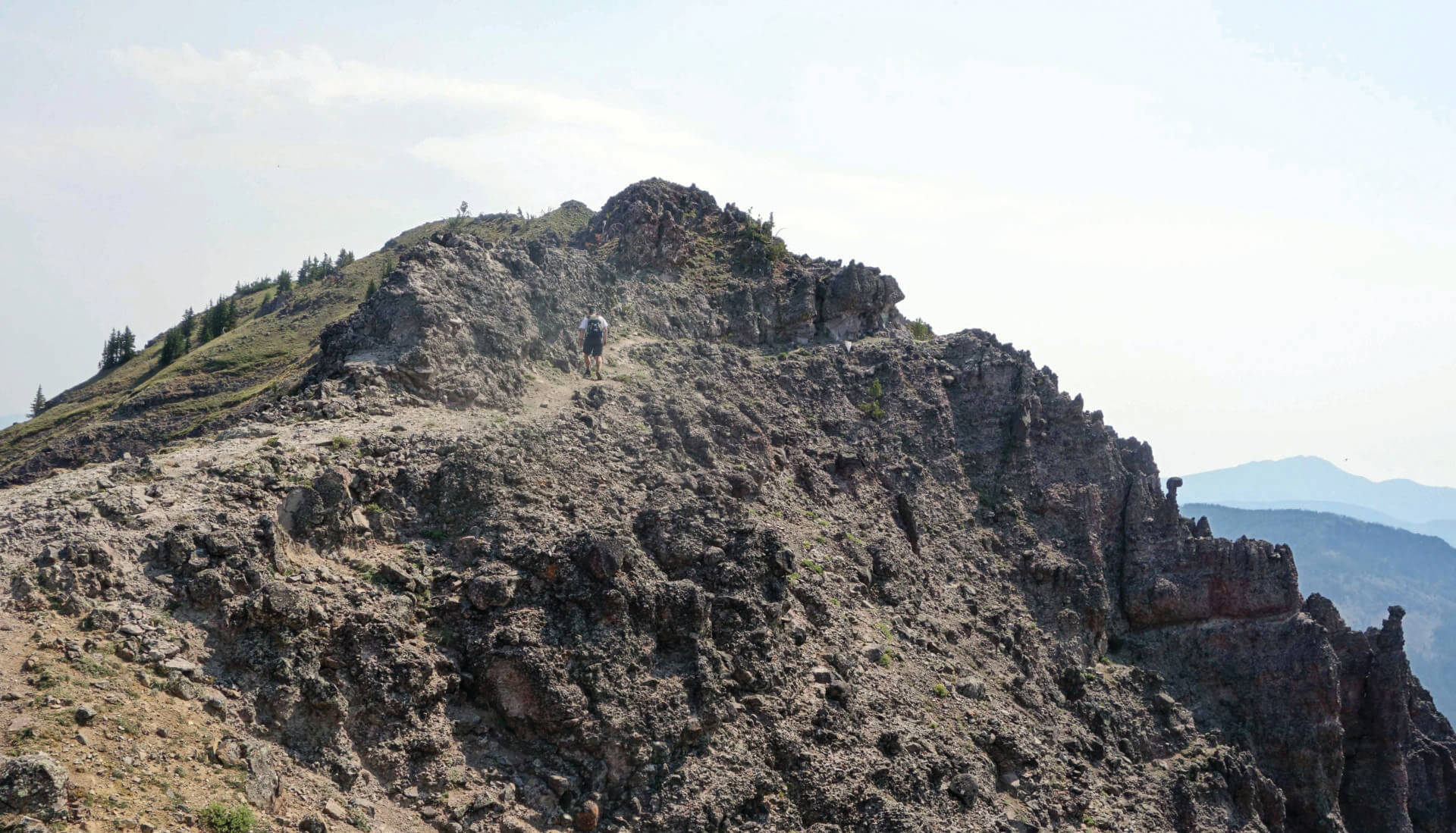
The Sky Rim Trail is unlike any other trail in Yellowstone. Seven of its 20 miles are on a ridge that undulates between 9,000 and 9,800 feet, offering extensive alpine vistas.
The Sky Rim trail is also barely in Yellowstone. The ridge itself is on Yellowstone’s northwestern boundary. Or, more correctly, it is Yellowstone’s northwestern boundary. Walking this section, which stretches between Daly Pass and Big Horn Peak, you pass metal stakes delineating the edge of the park at regular intervals.
From the Daly Creek Trailhead north of West Yellowstone, Montana, it’s about five miles and 2,000 vertical feet up to Daly Pass, and then another mile or so to the Sky Rim ridge itself. Once on the ridge, head south, but make sure to look in all directions. The Gallatin and Absaroka Ranges are in front of you, but the Madisons—including the prominent Sphinx—are behind you.
Follow the ridge until a trail drops into Black Butte Creek, which eventually has a cut-off trail that will return you to the Daly Creek Trailhead.
Details: A 20-mile lollipop with 5,000 feet of ascent/descent; the “stick” part is two miles long.
Best for: Fit hikers looking for a long day.
What to know: There is no water available on the ridge itself; once on the ridge, neither is there protection from weather—do not do this hike if lightning and thunder are possible.
Also in the area: From the ridge, the 9,888-foot-tall summit of Big Horn Peak is only .3 miles off the Sky Rim trail.
Find it: The Daly Creek Trailhead is not in Yellowstone, but 30 miles north of the town of West Yellowstone off U.S. Highway 191. JH